|
|
Santa Clarita Valley's Federally Recognized Historic Sites
National Historic Landmarks, National Register of Historic Places
|
National Historic Landmark status is the highest level of recognition for a historic building, site, structure, object or district. National Historic Landmarks "are historic properties that illustrate the heritage of the United States." As of 2015 there are just over 2,500 National Historic Landmarks. Examples include the White House, Mount Vernon and Monticello. The National Register of Historic Places is the "official federal list of districts, sites, buildings, structures, and objects significant in American history, architecture, archeology, engineering, and culture." Listing in the National Register is the second-highest form of recognition and may include sites that have significance "to the history of their community, state, or the nation." As of 2015 more than 90,000 historic places are listed, including the roughly 2,500 National Historic Landmarks, which are automatically listed. As of 2015, there are two (2) National Historic Landmarks and 7 additional (9 total) National Register sites with the Santa Clarita Valley Historical Society's and SCVHistory.com's sphere of interest. Generally, that sphere is coterminous with the Upper Santa Clara River watershed and includes portions of Los Angeles, Ventura and Kern counties — from the Newhall Pass on the south to Piru on the west, up Piru Creek to the Tejon Ranch on the north, following Highway 138 and the San Andreas Fault eastward through the Hughes and Elizabeth Lake communities to the mouth of Soledad Canyon in southern Palmdale, thence back down through Mount Gleason and the western San Gabriels to the Newhall Pass. (Certain outlying areas are included when specific events or individuals tie them to the Santa Clarita Valley, such as the full length of the Los Angeles Aqueduct, the Cerro Gordo silver mines and the San Fernando Mission.)
Santa Clarita Valley's National Historic Landmarks
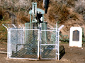
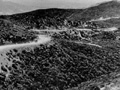
Well No. 4, Pico Canyon Oil Field
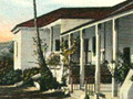
Rancho Camulos
Additional SCV Sites Listed in the National Register of Historic Places
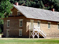
Fort Tejon
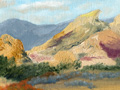
Vasquez Rocks
Ridge Route
Native American Rock Art Site
Native American Rock Art Site
Native American Rock Art Site
Native American Rock Art Site
(A fifth Native American rock art site, CA-LAN-1302 in Asuza, was listed the same day.)
Other National Register Sites of Local Interest
Lopez Adobe
Union Oil Company Building / Santa Paula Hardware Co. Block
Bardsdale Methodist Episcopal Church
Antelope Valley Indian Museum State Historic Park
About the National Register of Historic Places
|
• List of All SCV Sites • California's National Historic Landmarks
Pico Well No. 4
Rancho Camulos
Fort Tejon
Vasquez Rocks
Ridge Route
|
The site owner makes no assertions as to ownership of any original copyrights to digitized images. However, these images are intended for Personal or Research use only. Any other kind of use, including but not limited to commercial or scholarly publication in any medium or format, public exhibition, or use online or in a web site, may be subject to additional restrictions including but not limited to the copyrights held by parties other than the site owner. USERS ARE SOLELY RESPONSIBLE for determining the existence of such rights and for obtaining any permissions and/or paying associated fees necessary for the proposed use.
