|
|
Pyramid Lake and Substation Mark 26th Year
By Estelle Walton Foley
SCV Sheriff's Community Advisory Committee | Aug. 23, 2000
|
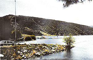
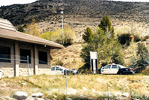
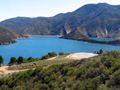
Pyramid Lake was built in 1973 by the state Department of Water Resources, operator of the state water system. Located amid the rugged hills of the Angeles National Forest in northern Los Angeles County, the lake's surface area covers 1,297 acres, with 22 miles of steeply rising shoreline spreading out to arm-like waterways through the canyons. Pyramid Lake is a reservoir of the California State Water Project, holding 180,000 acre-feet of water (about 58.5 billion gallons), imported by aqueduct 400 miles from Northern California. The water drops by tunnel 37,000 feet near Castaic Lake, spinning turbines at the Castaic power plant. The lake derives its name from the Pyramid Rock formation of the Piru Gorge, which forms one side of the dam. Ever since the completion of the dam and lake, law enforcement has been administered by the county of Los Angeles — first under authority of the Harbor Patrol, then by the Sheriff's Department. On June 30, 1974, the Pyramid Lake substation opened and was dedicated by then-Gov. Ronald Reagan. Sheriff's deputies are assigned from the Santa Clarita Valley Station. [The lake itself opened to the public Aug. 24, 1974 — Ed.] The six deputies at the Pyramid Lake substation are responsible for the enforcement of all laws — penal, fish and game, vehicle code and boating — for the lake and the nearby communities. The deputies are also charged with the education and safety of the 200,000-plus visitors to the lake each year. A boat launch ramp, swimming beach, picnic area and other facilities are available to the public. Summertime hours are 6:30 a.m. to 8 p.m.
|
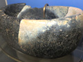
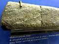
Steatite Cup, 1970 Elderberry Canyon Dig x5
|
The site owner makes no assertions as to ownership of any original copyrights to digitized images. However, these images are intended for Personal or Research use only. Any other kind of use, including but not limited to commercial or scholarly publication in any medium or format, public exhibition, or use online or in a web site, may be subject to additional restrictions including but not limited to the copyrights held by parties other than the site owner. USERS ARE SOLELY RESPONSIBLE for determining the existence of such rights and for obtaining any permissions and/or paying associated fees necessary for the proposed use.
