|
|
Santa Clarita Valley Organized Into Tejon Township.
Los Angeles County Board of Supervisors | August 14, 1855.
|
Webmaster's note.
Just one week after Surveyor-General Edward F. Beale acquired the first piece (Rancho La Liebre) of his eventual 300,000-acre Rancho El Tejon, the Los Angeles County Board of Supervisors organized the Santa Clarita Valley — from the San Fernando (later called Newhall) Pass on the south to the county line on the north — into the Tejon Township, a political jurisdition for electoral and other government purposes (Census, judiciary). The date was Aug. 14, 1855. At the same time, the supervisors established an electoral precict at the San Sebastian Indian Reservation as part of Tejon Township. We don't know why; Indians were denied the right to vote. But Beale was in charge. (The reservation, est. 1853, was located on the north side of the Tejon Pass, i.e., over the hill on the far side of the Grapevine, in the vicinity of the Sinks of Tejon.) Note that the county line on the north was the border with Tulare County, there being no Kern County until 1866. Kern was formed out of the southern part of Tulare County, with cessions from Los Angeles and San Bernardino counties — so the 1855 border was farther north than the present L.A.-Kern County line. Fort Tejon (1854-1864) and the Sinks of Tejon were in Los Angeles County. We're not certain when the Tejon Township became the Soledad Township (with altered boundaries), but it was probably 1873 when the Soledad Judicial District was formed.
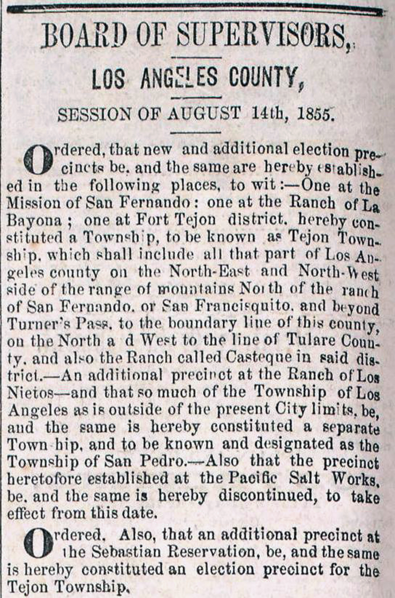
Board of Supervisors, Los Angeles County, SESSION OF AUGUST 14th, 1855. Ordered, that a new and additional election precincts be, and the same are hereby established in the following places, to wit: One at the Mission of San Fernando; one at the Ranch of La Bayona; one at Fort Tejon district, hereby constituted a Township, to be known as Tejon Township, which shall include all that part of Los Angeles county on the North-East and North-West side of the range of mountains North of the ranch of San Fernando, or San Francisquito, and beyond Turner’s Pass, to the boundary line of this county, on the North and West to the line of Tulare County, and also the Ranch called Casteque in said district. An additional precinct at the Ranch of Los Nietos — and that so much of the Township of Los Angeles as is outside of the present City limits, be, and the same is hereby constituted a separate Township, and to be known and designated as the Township of San Pedro. Also that the precinct heretofore established at the Pacific Salt Works, be, and the same is hereby discontinued, to take effect from this date. Ordered. Also, that an additional precinct at the Sebastian Reservation, be, and the same is hereby constituted an election precinct for the Tejon Township. Courtesy of Stan Walker.
|
|
The site owner makes no assertions as to ownership of any original copyrights to digitized images. However, these images are intended for Personal or Research use only. Any other kind of use, including but not limited to commercial or scholarly publication in any medium or format, public exhibition, or use online or in a web site, may be subject to additional restrictions including but not limited to the copyrights held by parties other than the site owner. USERS ARE SOLELY RESPONSIBLE for determining the existence of such rights and for obtaining any permissions and/or paying associated fees necessary for the proposed use.
