|
|
Over the Range to the Golden Gate (Excerpts).
By Stanley Wood.
R.R. Donnelley & Sons Co., Publishers, 1896 (1884).
Descriptions of towns along rail lines from north and west into the Santa Clarita Valley.
WEBMASTER'S NOTE.
Other publishers jumped on the bandwagon to capitalize on the phenomenon. Countless "travel guides" assuaged the public's appetite for more details of the landscape Jackson described. One such fairly nondescript albeit oft-republished guide was "Over the Range to the Golden Gate" (as San Francisco was known prior to the 1937 bridge of the same name). First appearing in 1884, coincident with "Ramona," author Stanley Wood uses the Missouri River as his jumping-off point, taking the traveler by rail to Denver and on to Los Angeles and San Diego, then northward into Washington Territory, as Wood supposedly had done himself, describing the scenery and the whistle stops along the way.
While the book is filled with illustrations by multiple artists, it gives us no clue as to whether "Stanley Wood" is Stanley L. Wood (1866-1928), a prolific London illustrator who focused on American Western themes. Doubters might speculate that the publisher sought to mimic a famliar name; it wouldn't be the first time.
Copyrighted by S.K. Hooper and published by R.R. Donnelley & Sons Co., an imprint of The Lakeside Press in Chicago, the book makes "every effort [to] state such facts as the traveler would like to know, and to state these facts in clear and explicit language." The preface repeatedly insists that its information is "statistically accurate" and devoid of "bias in any direction," while professing that the countryside "abound[s] in scenes of the greatest variety, from the broad and billowy expanse of the boundless prairie to the rugged grandeur of the American Alps, from the picturesque quaintness of New Mexico and the nomadic wildness of the Indian reservations to the polished civilization of metropolitan cities. ... What a field for investigation, investment or pleasure! These are the lands of gold, of silver, of coal, of agriculture, of all fruits known to the temperate and sub-tropical zones. These are the lands of new endeavors, of fresh impulses, and for these reasons are of special interest to tourists, business men and seekers after health and pleasure."
It is "[t]he truth, and nothing but the truth" (pg. 7); with such "accurate" depictions, who could resist the call?
The excerpts below are taken from the 1896 edition, which has been "revised and corrected to date." Not having seen the 1884 edition, we don't know what has changed, but the 1896 version accepts as fact that "Ramona" is set at Camulos, and it goes so far as to say that Jackson wrote portions of the book there (she didn't). Some things must have changed, because the writer can't have traveled from Santa Barbara to the Saugus depot by rail in 1884. The spur line and depot didn't open until 1887 — lending credence to the notion that the work might be a compilation and the purported author fictitious. Nowhere is it suggested that the author made a second trip. "Statistically accurate" or not, something is amiss. (It should be mentioned that while some sources cite an initial copyright date of 1894, we've seen 1889 and 1891 editions. Had it truly been 1894, or any other time after 1887, surely Saugus would have been mentioned as a stop on the initial trip south to Newhall. It wasn't.)
Considering the detail elsewhere, it is curious that no mention is made of the diner inside the Saugus depot (Tolfree's Eating House). We'll let stand the characterization of Newhall's depot as "not very large" (Saugus was bigger), and we can probably forgive Mr. Wood for never having heard of Joshua trees (a name given by Mormon settlers in the mid-1800s); "yucca palm," used herein, is a valid alternative.

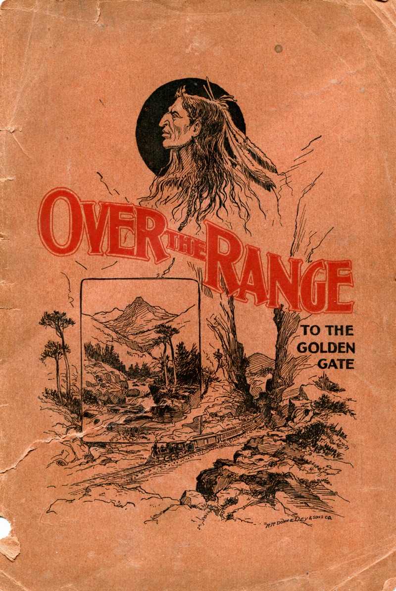
Cover to the 1896 edition. Click image to enlarge.Incongruities notwithstanding, there is certain value to the work. Taken for what they are, the entries in "Over the Range" expand our understanding of the way Southern California communities were presented and promoted to outsiders.
For the sake of zeroing in on the Santa Clarita Valley and its environs, we pick up the journey at Bakersfield and head south over the Tehachapi Loop to Newhall (pp. 183-186). We omit the lengthy and ebullient description of Los Angeles and the side trip by boat out of San Pedro to the pastoral, pre-1925-earthquake Santa Barbara, and pick up again on the rail line from Ventura (San Buenaventura) through the Santa Clara River Valley to the depot at Saugus (pp. 193-196).
Some items of local note are the crops that were grown; Newhall's hotel could accommodate 150 guests, and the vineyards were thriving at Camulos, which boasted a population of 120. While dutifully acknowledging the "attractive character" of the latter's scenery, the author does the modern reader a disservice when he perfunctorily dismisses Acton's depot as uninteresting. What is interesting, through today's lens, is his characterization of the passage from the Antelope and Santa Clarita Valleys into the citrus orchards of the San Fernando Valley: He calls it a transition from an "arid waste" to something "very opposite in character."
What a difference a century makes.
For descriptions of other towns along the route from Denver to San Diego and thence to Seattle, follow this link to download a plain text file of the entire book, or look for an original copy of the illustrated book in the Santa Clarita Valley Historical Society Library at Heritage Junction in Newhall's William S. Hart Park.
— Leon Worden, 2012
Bakersfield is the county-seat of Kern County, situated at the junction of the two forks of Kern River. The town has the usual complement of public and private buildings. It is surrounded by an exceedingly fertile country. Fourteen miles southwest is Kern Lake, seven miles long by four wide, while six miles farther is Buena Vista Lake, a somewhat larger body of water. Irrigation has been brought to great perfection in this county, there being seven hundred miles of irrigating canals within its limits, the largest having a width of one hundred feet and a length of forty miles. Twenty-five miles southwest of Bakersfield are the Buena Vista Oil Works. This oil region, eight miles long by three wide, only needs development to become an exceedingly valuable property. Bakersfield has, as may be seen by the above, a most productive country surrounding it. (Population, 2,500. Distance from San Francisco, 314 miles. Elevation, 415 feet.)
Caliente. This station is at the entrance to the famous Tehachapi Pass, and is located in the embrasure of a deep and narrow canon, up which the train takes its difficult way. This is a shipping point for freight from interior points delivered to the road by wagons. It is also quite a stage station, stages leaving Caliente (or Basin, Havilah, Hot Springs, Weldon and Kernville. (Population, 50. Distance from San Francisco, 336 miles. Elevation, 1,290 feet.)
The twenty-four miles of journey up and down the Sierra Nevadas, at the point where the railroad makes the passage of this range dividing the broad valley of the San Joaquin and the desert of Mojave, is a most remarkable experience, and brings before our -eyes the wonderful triumph of railway engineering skill. It is alleged that three civil engineers of great reputation first undertook to survey a passage through these peaks and crags, and, after repeated attempts, declared the route impassible. A boy of twenty took up the work where his elders had forsaken it, and this miraculous railway path over and through the mountains is the result. Concerning this famous pass, Mr. E. McD. Johnstone writes graphically as follows:
"As the Sierra Nevada and Coast Ranges in the north culminate in the great peak of Shasta (41° 24'), so in the neighborhood of Tehachapi Pass (35°) these two great chains blend their distinguishing features of fern slope and icy crag, and are lost in an inextricable mass of jumbled up peaks of every conceivable form and variety. Although nature has reared no such colossal masterpiece as Shasta in the welding of her great rock bands in the South, she has managed to throw up her earth-works in a manner so impregnable as to seemingly defy the art of man to penetrate. The physical features of this Tehachapi country (the lowest pass being 4,000 feet altitude) seemed to, and did for a time, baffle the shrewdest engineers, but, finally, the track, by doubling back upon, and crossing itself, by climbing, squirming and curving, resulted in a success and gave us one of the most famous and dextrous [sic] pieces of railroad engineering in the world."
Tehachapi Summit. The station at the summit of the pass is at an elevation of 3,964 feet, and is the highest point on this extension of the line. Sheep feed on the grass, which is abundant in the valleys and gulches which surround the station.
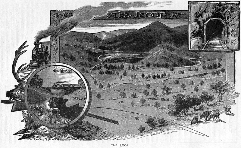
Tehachapi Loop. Click image to enlarge.Descending to the Desert. For Several miles the train rolls along on a level plateau on the summit of this range before the descent to the Mojave Desert is made. A small salt lake is passed, where abundance of the chloride of sodium, that important article of commerce, can be shoveled up from the bed of the lake, it being entirely exposed during the summer by the evaporation of its waters.
Cameron is a small station passed about midway between the summit and Mojave, at the base of the range.
Mojave is on the edge of the desert of the same name, and the water used s brought in pipes from Cameron, a distance of ten miles. This place is the junction of the Atlantic and Pacific Railroad with the Southern Pacific. (Population 300. Distance from San Francisco, 382 miles. Elevation, 2751 feet.)
The Mojave Desert. A desert isn't as a general rule much of an object of interest to travelers, especially to those who have made the transcontinental journey and experienced the monotony of the deserts of Utah and Nevada. However we must say this, that we found many things to interest us while traversing the famed sand wastes of Mojave. In the first place there were the giant Cacti or Yucca Palm, a sight novel to our eyes, and peculiar in and of itself. This cactus grows to the size of a tree, reaching an average height of twenty-five feet, and attaining very often that of fifty feet. Its diameter is often that of two feet, and sometimes even greater; with its spreading club-like branches, its trailing bark and peculiar form, the Yucca Palm is indeed an interesting feature in the landscape. Another attraction is the peculiar form of the buttes, which rise from the desert sands on every side. Varying in height from two to five hundred feet, grooved and channeled by the elements, they give variety and interest to the landscape. One must not neglect to mention the mirage as a third element of variety. We do not remember ever to have seen more complete or deceptive mirage effects than those of the Mojave Desert.
Rosamond, Lancaster, Acton are desert stations of small interest. The Solidad Mountains tower to our right as Rosamond is passed, and we later on make our way through this range by means of what is known as the Solidad Pass, reaching an altitude of 3,211 feet.
Newhall. This station is not very large, but boasts a large hotel, capable of entertaining one hundred and fifty guests. From here may be plainly seen the San Fernando Mountains, exceedingly perpendicular, and rising to an altitude of three thousand feet. These mountains could not be passed until a tunnel six thousand nine hundred and sixty-seven feet long had been made.
In this vicinity are oil refineries producing about five thousand barrels of oil per day. The oil fields are but a short distance from Newhall.
San Fernando Tunnel. From Newhall we ascend the grade through cuts until the tunnel is reached. The grade is one hundred and sixteen feet to the mile, and as we approach from the north in the tunnel, it is thirty-seven feet per mile, the grade on the south from the exit is one hundred and six feet, while the elevation of the tunnel is one thousand four hundred and sixty-nine feet.
San Fernando. The valley of San Fernando bursts on our vision as we emerge from the tunnel, a land of orange groves and olive trees, the very opposite in character from the arid waste we have just left behind us. The town of San Fernando is quite a place, and growing daily in population.
Through cultivated fields, past suburban residences we roll, pausing for a moment at Burbank, only eleven miles from Los Angeles. Beyond this place we journey through villages de facto, de jure or in future. There are plenty of lot stakes, and the suburbs of Los Angeles will certainly be wide spread, if they ever cover the ground now laid out.
[...] Pages omitted as the writer continues to Los Angeles, then by boat from San Pedro to Santa Barbara, then by rail to Ventura, aka San Buenaventura.
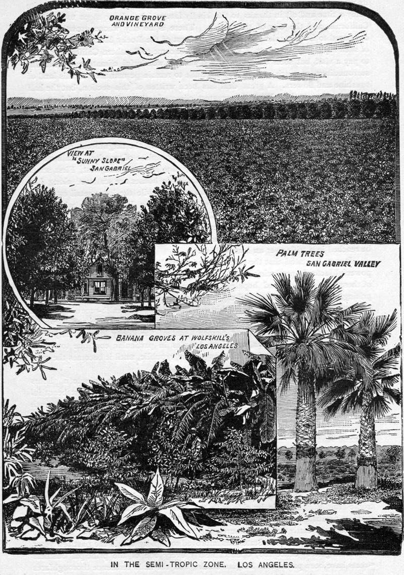
Fertile Los Angeles. Shown are the Wolfskill family's banana groves. William Wolfskill (1798-1866) in 1831 was one of L.A.'s first American immigrants and is reputed to have planted the area's first orange groves outside of mission lands. Locally, Wolfskill was the Del Valle family's lender. In the 1860s, when drought decimated the agribusiness on the Del Valles' Rancho San Francisco (i.e., the western Santa Clarita Valley), Wolfskill foreclosed. The Del Valles managed to hold onto 1,340 acres — the Camulos section — of their former 48,000-acre rancho. Wolfskill sold the balance in 1865 to oilman Thomas Bard. That's why, a decade later, when Henry Newhall purchased the Rancho San Francisco, it was a 46,460-acre rancho, not the standard 48,000 acres. Click image to enlarge.
San Buenaventura. The city of San Buenaventura, since the advent of the Southern Pacific Company, has made progressive strides. It is a beautiful, old, ex-Spanish town, with 3,000 population, and is the county seat of Ventura county. It is beautifully located upon the seashore, just at the point where the Ventura river breaks through the sand into the sea. There are not many costly or elegant residences, but rather more than the usual proportion of neat, cosy [sic] homes. The same thing is true of the business blocks, and the town has its full complement of stores and shops of all kinds. The streets have solid concrete walks and tile sewerage throughout the town. It is well lighted with gas, and has very efficient water-works. The hotels are good and well patronized. There are the usual number of churches, schools and fraternal organizations. The town is lively and a large volume of business has always been transacted. The climate is delightful and life here must be a continual delight.
"And oh I the balmy air 'tis bliss to breathe,
As through the mountain gap steals the fresh breeze,
Tempering the fervid summer's noonday heats
With the gentle breath of mild Pacific seas."San Buenaventura has until within a comparatively recent date, been, in a measure isolated from the great centers of trade, not only of California but of the world; but now that the Southern Pacific Company has been built through its confines, it has entered upon an era of unexampled prosperity. The road enters the Southeastern part of the county by the way of Newhall, and extends to the coast at San Buenaventura, tapping a tract of country that for fertility cannot be surpassed Los Angeles is but a few hours' ride distant; and the varied products of this section find a ready market. (Population, 3,000. Distance from San Francisco, 500 miles. Elevation, 45 feet.)
Fertile Valleys. The great Santa Clara of the South is celebrated for the fertility of its soil, mildness of climate, and healthfulness of its people. It was this valley and its tributaries that enabled Ventura county at the Mechanics' Fair at San Francisco, in 1885, to carry off the first premium for the most extensive and varied exhibit of farm products. The valley extends nearly east and west across j the county, and is traversed by the Santa Clara river, fed by numerous tributaries, as the Castaic, Piru, Sespe and Santa Paula. At the upper or east end is the San Francisco ranch, which includes the wheat-growing ranch of the Newhall Brothers, and the Camulos with its orange and olive orchards, wine-cellars and old vineyards, made famous by Mrs. Jackson, who wrote a part of her celebrated book, "Ramona" at this place. San Francisco ranch contains about 12,000 acres; the Sespe ranch 8,000, well adapted for citrus and deciduous fruits; the Saticoy Rancho, 17,000 acres; Bardsdale, a 2,ooo-acre colony; thence southerly, the Colonia rancho of 45,000 acres, level as a floor. Intervening is the Rancho Santa Clara del Norte, of 13,000 acres. Next there is the San Miguel rancho, of 5,000 acres — an immense corn, bean and grain field. When we have passed through this rancho en route for Los Angeles, we are in the Ex-Mission, the grant upon which is located the beautiful and thriving palm city, San Buenaventura. This rancho includes about 48,000 acres, mostly hill lands, lying north of Santa Paula and Saticoy. Among its hills are some beautiful tracts, well wooded and watered. In this great valley the Santa Clara of the South, a large population can be sustained. Its wonderful resources, climate and scenery attract the attention of home-seekers.
The Ojai valley is a great amphitheater, whose walls are mountains rising like citadels in all directions. Overlooking the whole is Mt. Topo-topa, rising to a height of from five to six thousand feet, and coming out in springtime from the snows of untold winters as fresh and beautiful as ever. The drive to lower Ojai is exceedingly inviting, being an easy grade along a clear, beautiful stream alive with trout. In many places the road is arched with sycamore, oak and other trees, festooned with hanging mosses and vines, and made vocal by the songs of birds. In the valleys the air is soft and balmy as that of the island of Atlantis of fabled story. They are the resort of invalids and pleasure-seekers, who receive the best attention and care at a very moderate price.
Montalvo is another prospective city, with great beauty of situation, really a suburb of San Buenaventura, but no great business interests at present. (Distance from San Francisco, 495 miles. Elevation, 89 feet.)
Saticoy. This pretty little town is situated in the midst of a fruit, grain and vegetable growing region. Population, 300. Distance from San Francisco, 491 miles. Elevation, 146 feet)
Santa Paula is one of the leading towns in Ventura county and is fifty miles north of Los Angeles. It has a growing population and is located in the center of the beautiful Southern Santa Clara valley, which has the most productive soil in the world, producing anything that mother earth can bring forth. Grain, corn, beans and tropical fruits are raised in abundance, and are unsurpassed in quantity and quality. There is one orange orchard near the town consisting of one hundred acres, which is the finest we ever saw.
For climate and health, Santa Paula and its surroundings are unexcelled. The water supply is abundant from cooling springs in the near mountains. The fins gardens of vegetation and flowers ripen and bloom the whole year round. In fact, it is a land overflowing with milk, honey—and oil.
Santa Paula is the headquarters of the oil regions of California. The most extensive Petroleum Oil operations are on the Rancho Ex-Mission, situated along the south side of Sulphur Mountain, beginning about four miles northwest of the town and extending in a westerly direction eight miles, these wells are owned and operated by a company which is incorporated with a capital stock of $1,000,000. This company has been most successful in its development, having a daily production of about 1,000 barrels from the many wells and tunnels. The region is a network of pipe lines conveying the oil to Santa Paula, Ventura and Hueneme. The largest well produces about 300 barrels daily. The next most extensive oil developments in this region are located at the Sespe, owned and operated by the Sespe Oil Company, with its office at Santa Paula. The company has a capital stock of $250,000. The production of the region is about 275 barrels daily, which is piped to Santa Paula. These two companies keep a large force of men constantly engaged in drilling new wells, and thus the production is being constantly augmented. No industry in the Golden State promises better results than its oil developments, and nothing is more beneficial to Ventura county, and to Santa Paula in particular. With an abundance of cheap petroleum for fuel, no section offers better advantages for manufacturing purposes. (Population, 1,300. Distance from San Francisco, 483 miles. Elevation. 286 feet.)
Camulos. This picturesque hamlet has been made known to the world of book readers as the home of "Ramona." The scenery surrounding it is of the most attractive character. The San Fernando mountains are on the south, the foot-hills of the Sierra de San Rafael on the north, the Santa Clara river flows through the sylvan valley that lies between. On its margins are clumps of willows and groves of wide-spreading sycamores, and near where its clear waters run by the old homestead, may be seen the " artichoke patch," and the "flat stone washboards, on which was done all the family washing." The house, as described by Mrs. Jackson, was "one of the best specimens to be found in California of the representative house of the half barbaric, half elegant, wholly generous and free-handed life led there by Mexican men and women of degree in the early part of this century." The foot hill pasture lands, the sheep corrals, the vineyards, olive groves and orchards, the old Chapel, etc., etc., are all to be seen quite as really as they are described in this interesting book. Mrs. Jackson's descriptions of Southern California scenery are exceedingly fine, and it is not a matter of wonder that she chose this beautiful spot as the home of her charming Ramona. Camulos presents opportunities for the establishment of ideal homes in the heart of ideal scenery. (Population, 150. Distance from San Francisco, 463 miles. Elevation, 286 feet.)
Saugus. Junction of the Ventura Branch with the main line. Our journey from here to Los Angeles has already been described.


The site owner makes no assertions as to ownership of any original copyrights to digitized images. However, these images are intended for Personal or Research use only. Any other kind of use, including but not limited to commercial or scholarly publication in any medium or format, public exhibition, or use online or in a web site, may be subject to additional restrictions including but not limited to the copyrights held by parties other than the site owner. USERS ARE SOLELY RESPONSIBLE for determining the existence of such rights and for obtaining any permissions and/or paying associated fees necessary for the proposed use.
