
Page 833 - anf1995elsmere_deis
P. 833
_ boundary between the two major basins is located along the steep ridgeline traversed by
East Firebreak Road (Figure 12 and Plate 7A), and continues to the west at the crest of San
Fernando Pass into the Santa Susana Mountains. Most of the project property lies
northwest of this divide and therefore falls within the Santa Clara River Basin drainage
area, with the smaller portion of the property southeast of the divide included within the
Los Angeles River Basin. The proposed landfill footprint lies entirely with the Santa Clara
River Basin surface drainage area (Figure 12). These two hydrologic basins and their
subunits and divisions applicable to the regional hydrogeologic setting of the project
property are discussed below.
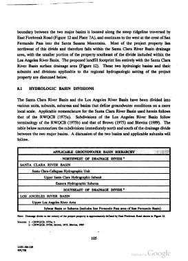
8.1 HYDROLOGIC BASIN DIVISIONS
The Santa Clara River Basin and the Los Angeles River Basin have been divided into
various units, subunits, subareas and basins that define groundwater conditions on a more
local scale. Applicable nomenclature for the Santa Clara River Basin used herein follows
that of the RWQCB (1975a). Subdivisions of the Los Angeles River Basin follow
terminology of the RWQCB (1975b) and that of Brown (1975) and Blevins (1989). The
table below summarizes the subdivisions immediately north and south of the drainage divide
between the two major basins. A discussion of the two basins and applicable subunits will
follow.
I
- NORTHWEST 0F DRAINAGE DIVIDE '
I SANTA CLARA RIVER BASIN
Santa Clara-Calle - Hydr ahic Unit
Upper Santa Clara Hydrographic Subunit
Eastern Hydrographic Subarea
1 SOUTHEAST 0F DRAINAGE DIVIDE’
‘ LOS ANGELES RIVER BASIN
l
Upper Los Angeles River Area
Sylmar Basin or Subarea (includes San Fernando Pass area of San Fernando Basin)
Note: Drainage divide in the vicinity of the project property is approximately defined by East Flrebreak Road shown in Figure 12.
Sources: 1 - CRWQCB, 1975a; b
2 - CRWQCB, 1975b; Brown, 1975; Blevins, 1989
105
21351-000128
' 009/708