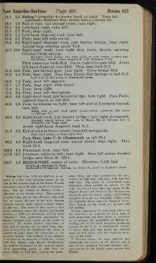
Page 473 - autobluebook1920vol8
P. 473
Los Angeles Section  Page 455     Route 415
   18.1  2.6 Bishop,* irregular 4-corners, bank on right.  Turn left.
         GARAGES—Watterson Bros. Garage, Main & Academy Sts.
   22.6  4.5 End of road, just beyond creek; turn right.
   23.4  0.8 Left-hand road; turn left.
   26.1  2.7 Fork; bear right.
   27.5  1.4 Left-hand diagonal road; bear left.
   33.2  5.7 Fork; bear left with travel.
   33.4  0.2 Right-hand diagonal road, just beyond bridge; bear right.
        Ascend long winding grade 34.8.
   44.2 10.8 Right-hand road; turn right thru  fords,  shortly entering
        Crooked Creek canyon.
           Straight ahead before  this turn leads  to new bridge (under con-
           struction), which, when completed, will eliminate fords.
        Thru numerous fords 51.8. Curve right thru gate 52.8. Avoid
        left-hand diagonal road 54.9.  Thru deep ford 55.3.
   56.2 12.0 Fork, just beyond gate; bear right.  Cross bridge 60.5.
   60.6  4.4 Fork; bear right.  Pass Casa Diablo Hot Springs on left 61.3.
           Left fork at 60.6 leads to Mammoth Camp.
   68.0  7.4 Fork; bear left upgrade.
   69.7  1.7 Fork; bear right with travel.
   75.8  6.1 Fork; keep right.
   79.2  3.4 Fork; bear left downgrade.
   84.0  4.8 Right-hand road, just beyond bridge; turn right.  Pass Farm-
        ington’s Ranch on left 85.6.
   86.9  2.9 Fork, farmhouse on right; bear left and at 3-corners beyond,
        turn left.
           Right fork  is new road under construction,  rejoining  this route
           at mileage 91.3.
   89.3  2.4 Right-hand road, just beyond bridge; turn right downgrade.
           Straight ahead before this turn  is Route 295 at mileage  33.4  to
           Yosemite via Tioga pass.
        Avoid right-hand diagonal road 91.1.
  117.3
   91.3  2.0 End of road at fence corner; turn left downgrade.
           New road comes In from right 91.3.
         Pass Mono Lake P. O. (Hammond) on left 93.4.
   95.2  3.9 Right-hand diagonal road, school ahead; bear right.  Thru
        wash 98.3.
  103.6  8.4 Prominent fork; bear left.
      13.7 3-corners, cabin on left; bear right.  Bear left across wooden
        bridge onto Main St. 122.5.
  122.7  5.4 BRIDGEPORT, center of town.  Elevation 6,465 feet.
          HOTELS— Bridgeport Hotel.
          GARAGES— Bridgeport Garage, on Main  St., next to Wedert s store.
   •Bishop, Cal. (pop. 1,500, alt. 4,347 ft.), is  sit-  ators  there, and then successively the gen-
  uated  in a  fine  fruit growing region  at the  erators at 6,276 feet, 5,156 feet, 4,730 feet and
                                    transmitted upon
  foot of the eastern slope of the Sierra Nevada  4,460  feet.  The power  is
                        aluminum  wires  carried  on  towers  for  250
  mountains about 40 miles north of Independ-
                        miles southward over hills and plains to the
  ence.  Not  far  distant  is  Bishop  creek,  a  Mojave desert and thence to San Bernardino,
  tributary of the Owens river.  This creek  is  is being
                        Riverside and the Perris valley, and
  14 miles long and  in this distance  falls  5,500
                        extended through the Coachella Valley, over
  feet, or nearly 400 feet  to the mile, flowing  the Colorado desert into the Imperial valley.
  between canyon walls whose average height  Near Bishop on the north are geysers and
  is 1,000 feet. The water of this creek  is used  hot springs.
  seven different times  for electric generating  Several companies are operating plants  for
  stations at different elevations, driving them  the treatment  of tungsten ore on a scale of
  “tandem.”  Two  reservoirs  surrounded  by  such magnitude and with mines so extensive
  almost vertical  cliffs nestle at the heads  of  as  to presage the  possibility  of Bishop  be-
  canyons.  To  secure  perfect  regulation  of  coming one of the chief tungsten producing
  flow and to prevent  ice or snow from clog-  centers of the U.  S. A considerable number
  ging or injuring the machinery the water  is  of  silver,  lead and  zinc mines  are  likewise
  carried  in pipes from  the reservoirs  to  the  more or less  allied with the business  inter-
  seventh station.  The highest of the stations  ests of the town.
  is situated at an elevation of 8,000 feet, nearly  El Camino  Sierra, the  state highway that
  1,000  feet  higher  than Mount  Washington,  commands  the passes  of the Sierras and  is
  the highest mountain  of the eastern  states.  part of the proposed National Defense high-
  After  generating  power  at  8,000  feet,  the  way system for the Pacific coast, passes thru
  water drops to 7,112 feet, turning the gener-

