
Page 473 - calmining1890
P. 473
ANCIENT RIVER BEDS OF FOREST HILL DIVIDE. 443
volcanic mud formed a more compact conglomerate of the heavier
debris in the central line of flow, and a lighter and more sandy cement
toward the shore lines; and that these conditions tended to divert the
streams toward the marginal lines of the deposit. The streams would
necessarily cut across the deposit at the juncture of the volcanic-capped
tributaries.
There is offered no definite evidence in support of this assumption.
It is made, in default of a better one, with the view of impressing the
fact that the old cement channel has been avoided, to a notable extent,
by the channel of the modern rivers.
It is plain, however, that the reconstruction of the ancient systems is
very far from being so simple, as indicated in Fig. 5.
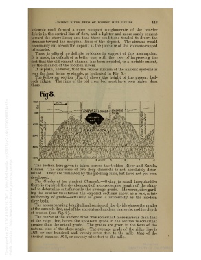
The following section (Fig. 8) shows the height of the present bed-
rock ridges. The rims of the old river bed must have been higher than
these.
3000
The section here given is taken across the Golden River and Eureka
Claims. The existence of two deep channels is not absolutely deter-
mined. They are indicated by the pitching rims, but have not yet been
developed.
The Grades of the Ancient Channels. — Owing to small irregularities
there is required the development of a considerable length of the chan-
nel to determine satisfactorily the average grade. However, disregard-
ing the smaller tributaries, the exposed sections show, as a rule, a fair
uniformity of grade — certainly as great a uniformity as the modern
river beds.
The accompanying longitudinal section of the divide shows the grades
of the summit line, and of the ancient and modern channels, and the depth
of erosion (see Fig. 9).
The course of the ancient river was somewhat more sinuous than that
of the ridge line, hence the apparent grade in the section is somewhat
greater than the actual grade. The grades are given in the form of the
natural sine of the slope angle. The average grade of the ridge line is
.024, or one hundred and twenty-seven feet to the mile; that of the
ancient channel .015, or seventy-nine feet to the mile.