
Page 787 - calmining1890
P. 787
TUOLUMNE COUNTY. 735
rly course, while the trend of the different formations is northwest.
The underlying gravel assumes different widths at intervals along its
;ourse, varying from fifty to sixty feet to several times that number. In
general, the bed is flat, and the gravel is more angular than in the great
Pliocene channels of Nevada, Sierra, and Placer Counties, etc. The
Smpire Claim is situated four miles southwest from the town of Sonora,
ind at this point the channel is about eighty feet in width. The cap-
ring of basalt is about six hundred feet wide and one hundred and fifty
eet thick. The erosion seems to have been at this point confined
lills and ridges; while west, Woods' Creek runs at a depth of about four
irincipally to the west side of the table, the east side going off into low
aundred feet from the top of the table. The gravel here is separated
n about the center of the channel by twenty feet of the volcanic matter,
•jvhich seems to have thrown the gravel to either side, it running from a
: feather edge to a thickness of about ten feet on either rim, where the
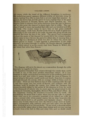
Richest gravel is found. I here append a cross-section of the table
nountain, at a point through it cutting the Empire channel longitudi-
nally, which tunnel is on the county road from Sonora to Milton, dis-
tant about four miles from Sonora:
The diagram will serve for almost any cross-section through the table
nountain, as regards its strata.
The limestone formation that courses through the county from north
T>o south is one of the most peculiar formations extant. It is very
rregular in width, varying from several miles at the northern part of the
limnty to a half mile where it passes through the town of Sonora, its
course being to this point nearly north and south; from here it courses
southeast through the county, with an average width of from a mile to
Iro miles. There are four distinct runs of slate coursing north through
t, and they merge into two south of Sonora, and continue with the
imestone until it reaches the county line, where the limestone has
Decome denuded, either by the action of the elements or from the work
)f the thousands of miners who in years gone by placer-mined in the
3nvirons of Columbia, Springfield, Brown's Flat, and Shaw's Flat. In
ihis immediate vicinity, the limestone is several miles in width. On
T
approaching the scene from a point w here the eye can take in a pano-
amic view, one is for a moment reminded of an inland sea, with its
surface covered with white-crested waves; but on close inspection the
formation shows itself in all possible and fantastic shapes. That the
;heory may be true that it was once the bed of a large sheet of water,
lighly impregnated with carbonic acid, and had eaten into the lime-
stone, forming it as it is, I do not doubt. To my mind, a chemical action
las undoubtedly taken place to form these shapes and crevices, varying
'n depth from a few feet to fifty and sixty feet, and no doubt much