
Page 480 - northlakehills_deir_0517
P. 480
NorthLake Specific Plan Draft Supplemental EIR Potential Sources Hydrology and Water Quality
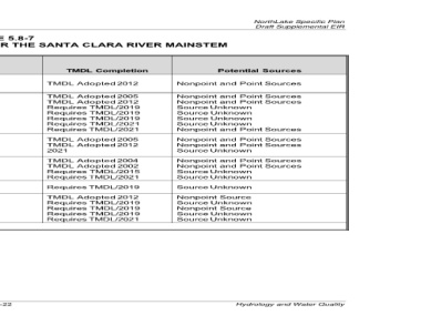
Nonpoint and Point Sources
Nonpoint and Point Sources
Source Nonpoint and Point Sources Unknown Source Unknown Source Unknown Unknown Source Nonpoint and Point Sources Nonpoint and Point Sources Nonpoint and Point Sources Unknown Source Nonpoint and Point Sources Nonpoint and Point Sources Unknown Source Unknown Source Unknown Source Nonpoint Source Source Unknown Nonpoint Source Source Unknown Unknown Source
TMDL Completion 2012 TMDL Adopted 2005 TMDL Adopted 2012 TMDL Adopted Requires TMDL/2019 Requires TMDL/2019 Requires TMDL/2019 Requires TMDL/2021 Requires TMDL/2021 2005 TMDL Adopted 2012 TMDL Adopted 2021 2004 TMDL Adopted 2002 TMDL Adopted Requires TMDL/2015 Requires TMDL/2021 Requires TMDL/2019 2012 TMDL Adopted Requires TMDL/2019 Requires TMDL/2019 Requires TMDL/2019 Requires TMDL/2021
TABLE 5.8-7 2010 CWA SECTION 303(D) LISTINGS FOR THE SANTA CLARA RIVER MAINSTEM Pollutants Solids
Coliform Bacteria Chloride Bacteria Coliform Chlorpyrifos Diazinon Toxicity Iron Copper Chloride Bacteria Coliform Iron Ammonia Chloride Total Dissolved Toxicity Toxicity Bacteria Coliform ChemA Toxaphene Toxicity Nitrate 2 2 - 8 . 5
and Lang 5) Bridge (30
Geographic Description
End of Reach Distance from Project to Upstream Bouquet Canyon Rd to above Gaging Station (5 miles upstream of West Pier Hwy 99 to Bouquet Cyn. Rd (Directly upstream of Reach Blue Cut Gaging Station to West Pier (Location where Castaic Creek joins Freeman diversion dam to “A” street (25 miles downstream of Reach 5) Estuary to Highway 101 miles downstream of Reach 5) (40 miles downstream of Reach 5)
Reach 5) Hwy 99 the Santa Clara River) Estuary
River Reach or Tributary 7 6 5 3 1 -- Source: Geosyntec 2015. R:\Projects\OC\WCP_Woodrid\J0001\Draft EIR\5.8 Hydro WQ-042617.docx