
Page 45 - ssmtmp2_final20181211
P. 45
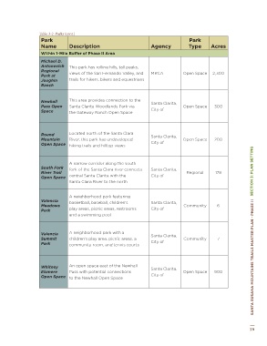
Table 3-2: Parks (cont.)  Table 3-2: Parks (cont.)
 Park   Park        Park                                                                Park
 Name  Description  Agency  Type  Acres  Name  Description            Agency            Type      Acres
 This historic park in Pico Canyon   Within 1-Mile Buffer of Phase II Area
 highlights the history of an old oil town   Michael D.
 and the presence of the oil industry   Antonovich   This park has rolling hills, tall peaks,
 in Pico Canyon; historic buildings, oil   Regional   views of the San Fernando Valley, and   MRCA  Open Space  2,300
 Mentryville  wells, and other equipment provide   MRCA  Historic   69  Park at   trails for hikers, bikers and equestrians
                    Joughin
 Park
 visitors a glimpse of the areas past; the   Ranch
 park now acts as a trailhead for many
 trails into the Santa Clarita Woodlands
 and provides restrooms and parking  Newhall   This area provides connection to the   Santa Clarita,
                    Pass Open    Santa Clarita Woodlands Park via                    Open Space    300
 Bordering Phase II Area  Space  the Gateway Ranch Open Space         City of


 Gateway   Located in the Newhall Pass, this area   Santa Clarita,
 Ranch Open  acts as an important wildlife corridor,   Open Space  302
 Space  and offers various recreational trails  City of  Round   Located north of the Santa Clara   Santa Clarita,
                    Mountain     River, this park has undeveloped                    Open Space    200
                    Open Space   hiking trails and hilltop views      City of
 A densely wooded portion of the
 SECTION 3: PLAN SETTING  Michael D.   accessed from trails at Towsley Canyon,   Los Angeles,   Open Space  500  South Fork   A narrow corridor along the south   Santa Clarita,   Regional  178  SECTION 3: PLAN SETTING
 Santa Clarita Woodlands which can be
 County of;
 Antonovich
 East Canyon, and Weldon Canyon
 Open Space
                                 fork of the Santa Clara river connects
 MRCA
                    River Trail
 Motorway, and connects southward to
                                                                      City of
                                 central Santa Clarita with the
                    Open Space
 the SSMFTMP (Phase I) study area
                                 Santa Clara River to the north
 SANTA SUSANA MOUNTAINS TRAILS MASTER PLAN - PHASE II
                    Valencia     A neighborhood park featuring        Santa Clarita,
                                 basketball, baseball, children’s
                    Meadows                                                          Community       6
                    Park         play areas, picnic areas, restrooms   City of
                                 and a swimming pool
                    Valencia     A neighborhood park with a           Santa Clarita,
                    Summit       children’s play area, picnic areas, a               Community       7
                    Park         community room, and tennis courts    City of


                    Whitney      An open space east of the Newhall    Santa Clarita,                                 SANTA SUSANA MOUNTAINS TRAILS MASTER PLAN - PHASE II
                    Elsmere      Pass with potential connections                     Open Space    900
                    Open Space   to the Newhall Open Space            City of


 Figure 3-5: Jake Kuredjian Park Features Large Lawn Areas and Dramatic Coast Live Oak trees

 38                                                                                                                39