
Page 37 - ssmtmp2_initialstudy20171102
P. 37
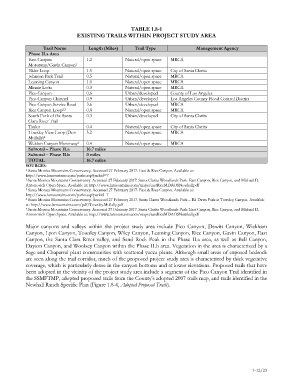
TABLE 1.8-1
                                 EXISTING TRAILS WITHIN PROJECT STUDY AREA

                   Trail Name         Length (Miles)     Trail Type                Management Agency
             Phase II.a Area
             East Canyon             1.2             Natural/open space  MRCA
             Motorway/Gavin Canyon 1
             Elder Loop              1.5             Natural/open space   City of Santa Clarita
             Johnson Park Trail      0.5             Natural/open space   MRCA
             Leaming Canyon          1.0             Natural/open space  MRCA
             Minnie Lotta            0.3             Natural/open space   MRCA
             Pico Canyon             0.6             Urban/developed    County of Los Angeles
             Pico Canyon Channel     0.9             Urban/developed    Los Angeles County Flood Control District
             Pico Canyon Service Road   3.6          Urban/developed    MRCA
             Rice Canyon Loop 2,3    0.8             Natural/open space  MRCA
             South Fork of the Santa   0.3           Urban/developed    City of Santa Clarita
             Clara River Trail
             Taylor                  0.4             Natural/open space   City of Santa Clarita
             Towsley View Loop (Don   5.2            Natural/open space  MRCA
             Mullally) 4
             Weldon Canyon Motorway 5   0.4          Natural/open space  MRCA
             Subtotal – Phase II.a   16.7 miles
             Subtotal – Phase II.b   0 miles
             TOTAL                   16.7 miles
            SOURCES:
            1  Santa Monica Mountains Conservancy. Accessed 27 February 2017. East & Rice Canyon. Available at:
            http://www.lamountains.com/parks.asp?parkid=7
            2  Santa Monica Mountains Conservancy. Accessed 27 February 2017. Santa Clarita Woodlands Park: East Canyon, Rice Canyon, and Michael D.
            Antonovich Open Space. Available at: http://www.lamountains.com/maps/eastRiceMDAOSNewhall.pdf
            3  Santa Monica Mountains Conservancy. Accessed 27 February 2017. East & Rice Canyon. Available at:
            http://www.lamountains.com/parks.asp?parkid=7
            4  Santa Monica Mountains Conservancy. Accessed 27 February 2017. Santa Clarita Woodlands Park – Ed Davis Park at Towsley Canyon. Available
            at: http://www.lamountains.com/pdf/Towsley.Mullally.pdf
            5  Santa Monica Mountains Conservancy. Accessed 27 February 2017. Santa Clarita Woodlands Park: East Canyon, Rice Canyon, and Michael D.
            Antonovich Open Space. Available at: http://www.lamountains.com/maps/eastRiceMDAOSNewhall.pdf

            Major canyons and valleys within the project study  area include Pico Canyon, Dewitt Canyon, Wickham
            Canyon, Lyon Canyon, Towsley Canyon, Wiley Canyon, Leaming Canyon, Rice Canyon, Gavin Canyon, East
            Canyon, the Santa Clara River valley, and Sand Rock Peak in the Phase II.a area, as well as Bell Canyon,
            Dayton Canyon, and Woolsey Canyon within the Phase II.b area. Vegetation in the area is characterized by a
            Sage and Chaparral plant communities with scattered yucca plants. Although small areas of exposed bedrock
            are seen along the trail corridor, much of the proposed project study area is characterized by thick vegetative
            coverage, which is particularly dense in the canyon bottoms and at lower elevations. Proposed trails that have
            been adopted in the vicinity of the project study area include a segment of the Pico Canyon Trail identified in
            the SSMFTMP, adopted proposed trails from the County’s adopted 2007 trails map, and trails identified in the
            Newhall Ranch Specific Plan (Figure 1.8-4, Adopted Proposed Trails).


                                                                                                          1-12/23