
Page 3 - squires2012
P. 3
Contributions in Science, Number 520 Squires: Pico Formation Paleontology & 75
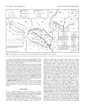
Figure 2 Geologic map of the study area south of Newhall, northern Los Angeles County, California.
A total of 2020 specimens were studied, and approximately half of Collectors: H.M. Rice (circa early 1930s) and R.L. Squires,
these specimens were personally collected. The figured specimens, as well October 1, 2011. 7752 [= 5547]. 118u319150W, 34u219080N.
as all the other megafossils collected in the course of this study, were Elevation 427 m (1400 ft.), northeast of trailer park in north–
deposited in the LACMIP collection. south-trending canyon, on south section-line, 91 m (300 ft.) east
Matrix was removed from the fossils by the use of hammer and chisel,
and, for fine cleaning, a high-speed drill. A systematic treatment for each of northeast corner of section 14. Locality represents float
megafaunal species is not given here because no new information was material from a bed located a short distance to the north at the
gleaned for most of the species collected during the present study. head of a box canyon with inaccessible vertical cliffs. Collectors:
Previous synonymies, distinctive morphologic characters, and stratigraph- H.M. Rice (circa early 1930s); L.G. Barnes and G. Campbell,
ic distributions, etc. are available for most of the species in works such as April 1965; and R.L. Squires, October 9, November 13, and
Arnold (1903), Grant and Gale (1931), Hertlein and Grant (1972), December 4, 2011. 7757. 118u329330W, 34u219150N. Elevation
Groves (1991), Davis (1998), and Squires et al. (2006). New information 525 m (1725 ft.), on ridgeline, 290 m (950 ft.) north and 1036 m
is given here in the ‘‘Systematics’’ section for newly recognized synonyms (3400 ft.) east of southwest corner of section 10. Collectors:
of the pectinid Argopecten invalidus and for two potential new species of
gastropods. Figures of the taxa listed in Table 1 are included here in order H.M. Rice (circa early 1930s) and R.L. Squires, October 21,
to verify this list, and the numerical order of these figures corresponds to 2011. 9659. 118u319140W, 34u209340N. Elevation 637 m
the systematic organization used for the faunal list. (2090 ft.), on ridgeline, 655 m (2150 ft.) north and 381 m
ABBREVIATIONS: Abbreviations used for locality and/or catalog (1250 ft.) east of southwest corner of section 24. Collectors: G.A.
numbers are CAS (California Academy of Sciences, San Francisco; Rynearson (1938) and R.L. Squires, September 4, 2011.
includes the Stanford University [SU] collection), and LACMIP (Natural Equivalent to loc. 212 of Grant and Gale (1931:102). 17916.
History Museum of Los Angeles County, Invertebrate Paleontology 118u329490W, 34u219330N. Elevation 434 m (1425 ft.), south
Section).
side of disused road near south end of housing tract south of
Calgrove Blvd., 899 m (2950 ft.) north and 168 m (550 ft.) east
LOCALITIES of southwest corner of section 10, T 3 N, R 16 W. Collector: R.L.
Squires, October 21, 2011. 17917 [= 7761 and approximately
All are LACMIP localities in the Pico Formation of upper 7226 and 10339]. 118u32947.50W, 34u219300N. Elevation 480 m
Pliocene age, and located relative to the United States Geological (1575 ft.), east side of power line road east of Gavin Canyon,
Survey Oat Mountain Quadrangle (7.5 minute), 1952 (photo- 747 m (2450 ft.) and 213 m (700 ft.) east of southwest corner of
revised 1969), Los Angeles County, southern California. section 10, T 3 N, R 16 W. Collectors: H.M. Rice (circa early
7725. 118u319400W, 34u209350N. Elevation 549 m (1800 ft.), 1930s); G.M. Dorwat, March 22, 1943; C.R. Stauffer, 1949; and
crest of spur at base of power-line tower, 703 m (2300 ft.) north R.L. Squires, October 21, 2011. 17918 [= 7760]. 118u329480W,
and 703 m (2300 ft.) west of southeast corner of section 14. 34u219280N. Elevation 450 m (1475 ft.), north side of power line