
Page 7 - squires2012
P. 7
Contributions in Science, Number 520 Squires: Pico Formation Paleontology & 79
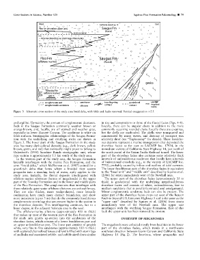
Figure 3 Schematic cross section of the study area braid delta, with folds and faults removed. Vertical exaggeration 35.5.
and argillite. Up-section, the amount of conglomerate decreases. in size and composition to those of the fluvial facies (Figs. 4–8).
Beds in the Saugus Formation commonly weather brown or Locally, there can be angular clasts in addition to the more
orange-brown, and, locally, are oil stained and weather gray, commonly occurring rounded clasts. Locally there are coquinas,
especially in lower Elsmere Canyon. The sandstone is white on but the shells are unabraded. The shells were transported and
fresh surfaces. Stratigraphic relationships of the Saugus Forma- concentrated by storm waves, and distance of transport was
tion with the underlying and overlying rocks are shown in relatively short (see ‘‘Taphonomy’’ for details). These fossilifer-
Figure 3. The lower part of the Saugus Formation in the study ous deposits represent a marine transgression that deposited the
area has many dark-colored deposits (e.g., dark brown, yellow shoreface facies as far east as LACMIP loc. 17934, in the
brown, green, and red) that eventually might prove to belong to immediate vicinity of California State Highway 14, just north of
Oakeshott’s (1950) Sunshine Ranch stratigraphic unit, whose the south portal of the Union Pacific Railroad tunnel. The lower
type section is approximately 5.5 km south of the study area. part of the shoreface facies also contains some relatively thick
In the western part of the study area, the Saugus Formation intervals of unfossiliferous sandstone that locally have intervals
laterally interfingers with the marine Pico Formation, and the of bidirectional crossbeds (e.g., in the vicinity of LACMIP loc.
term ‘‘braid delta,’’ which McPherson et al. (1987) coined for a 7752), probably caused by inflow and outflow of tidal currents.
gravel-rich delta that forms where a braided river system The lower fossiliferous part of the shoreface facies is equivalent
progrades into a standing body of water, aptly applies to the to the ‘‘basal unit’’ and ‘‘middle unit’’ described by Squires et al.
study area. Initially, the fluvial deposits interfingered with (2006) for strata immediately west of the Newhall area.
offshore-marine siltstones (barren of megafossils) in the upper The upper part of the shoreface facies (approximately 35 m
part of the Towsley Formation and in the lower and middle parts thick) is gradational with the underlying megafossiliferous
of the Pico Formation. The conglomerates that interfinger with shoreface facies and consists of white, unfossiliferous, fine to
these relatively quiet-water offshore siltstones are unfossiliferous. medium sandstone that is parallel-laminated and amalgamated.
They are also thicker, more wedge-shaped, more laterally Minor conglomeratic sandstone beds can also be present. The
continuous; have much more distinct boundaries; and show upper part of the shoreface facies crops out west of the Beacon
more incisement (up to 3 m) than do the commonly fossiliferous Fault to beyond U.S. Interstate Highway 5 and is the same as the
conglomeratic storm lags that are present higher in the section in ‘‘upper unit’’ described by Squires et al. (2006) from strata
the shoreface deposits. This interfingering continues, but to a immediately west of the Newhall area. The upper unit
lesser degree, in the adjacent Valencia area to the west. interfingers with the overlying Saugus Formation. East of this
The offshore-marine siltstone (approximately 450 m thick) fault the upper unit has been removed by erosion.
that makes up most of the western part of the Pico Formation in
the study area grades up-section into the sandstones of the OVERVIEW OF MEGAFOSSILS
shoreface facies, which consists of a lower fossiliferous part and
an upper unfossiliferous part. The lower part consists of grayish The megafossils were collected mostly from localities in the lower
white, very fine to fine sandstones (approximately 130 m thick) part of the shoreface facies, which trends in a northwest–
with scattered channelized lenses and lentils filled with storm lags southeast direction between Gavin Canyon and California State
of mollusks and associated pebble- and cobble-sized clasts similar Highway 14 (Fig. 2). The locations, whose geographic and