|
|
Gorman Area

Click image to enlarge
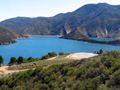
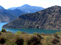
April 7, 2014 — Pyramid Lake (SWP reservoir), as seen from the Vista Del Lago Visitors Center.
Pyramid Lake California Department of Water Resources brochure, May 2000 Pyramid Lake is located in the Angeles and Los Padres National Forests, about 60 miles northwest of downtown Los Angeles. The lake's 21 miles of shoreline and 1,297 acres of surface area spread out into long, arm-like waterways and steep canyons. As a reservoir of the SWP [State Water Project], Pyramid Lake stores water for delivery to Los Angeles and other coastal cities of Southern California. It also provides regulated storage for Castaic Powerplant, flood protection along Piru Creek which it dams, and recreational opportunities. Lake Capacity: 171,200 acre-feet Surface: 1,297 acres Shoreline: 21 miles Maximum depth: 355 feet Dam Height: 400 feet Elevation: 2,606 feet Length: 1,090 feet Volume: 6,860,000 cubic yards History In 1843, gold was discovered near Pyramid Lake and in the Santa Feliciana Canyon, just south of what is now Pyramid Dam. But the small find failed to trigger a rush to the mountainous countryside. Only Francisco Lopes [Lopez], owner of Rancho Temescal, a Mexican land grant, and a handful of ranchers attempted to settle the region. Pyramid Lake and Dam, completed in 1973, were named after a pyramid-shaped rock carved out by engineers building the Old Highway 99. Travelers between Los Angeles and Bakersfield christened the landmark "Pyramid Rock," which still stands just adjacent to the dam. Powerplants The Department of Water Resources owns and operates the Warne Powerplant. Located on the Gorman Creek arm of the lake, the powerplant helps meet the Project's need for electricity. Taking advantage of the 739-foot drop to the lake surface, this plant, with a maximum rated capacity of 78 megawatts, can generate up to 358 million kilowatt-hours a year. Water flowing from Pyramid Lake through the 7.2-mile-long Angeles Tunnel spins the turbines in Castaic Powerplant. The 30-foot-diameter tunnel carries water on its way to coastal Southern California to Castaic Lake, the final Project reservoir on the State Water Project's West Branch. Castaic Powerplant generates electricity during on-peak periods (weekday daylight hours) when extra power is needed in the Los Angeles area. During off-peak periods (nights and Sundays) when local power is cheaper, the plant pumps water back into Pyramid Lake. The operation also reduces the cost of power required to move Project water from Northern to Southern California. Castaic Powerplant is a cooperative venture of DWR and the City of Los Angeles Department of Water and Power. Recreation Sites
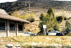
Fishing Fishing is allowed everywhere at Pyramid Lake. You can catch fish such as large mouth bass, small mouth bass, blue gill, crappie, and some trout. Boating Boating speed limits differ in parts of the lake. Canoes, rubber rafts and rowboats are often seen in the canyons where power boats are restricted to low speeds. Higher speeds for waterskiing are allowed on the main body of the lake. Water Levels The reservoir's water level can change every day because Pyramid Lake provides regulated storage for Castaic Powerplant. The recreation program at the lake is administered by a concessionaire operating under an agreement with the U.S. Forest Service. Vista Del Lago Visitors Center Vista Del Lago Visitors Center on Liebre Peninsula is among Pyramid's recreational points of interest. The 18,500-square-foot, Mediterranean-style building highlights interactive exhibits on California's water — its sources and its vital role in the state's quality of life. To get to the center from Interstate 5, take the Vista Del Lago road off-ramp.
The State Water Project California Department of Water Resources brochure, May 2000 Planned, designed, constructed and operated by the California Department of Water Resources (DWR), the State Water Project (SWP) is the largest state-built, multipurpose water project in the United States. The SWP, spanning more than 600 miles from Northern California to Southern California, includes 32 storage facilities, 17 pumping plants, 3 pumping-generating plants, 5 hydroelectric power plants, and approximately 660 miles of canals and pipelines. (This doesn't include the East Branch Extension, located in Southern California, which is under construction.) The SWP's main purpose is to provide water supply — that is, to divert and store surplus water during wet period and distribute it to areas of need in Northern California, the San Francisco Bay area, the San Joaquin Valley, the Central Coast, and Southern California. Other SWP purposes include flood control, power generation, recreation, fish and wildlife enhancement, and water quality improvement in the Sacramento-San Joaquin Delta. Twenty-nine urban and agricultural water agencies have long-term contracts for a maximum delivery of just over four million acre-feet of water per year. Of this amount, approximately 70 percent will go to urban users and 30 percent to agricultural users. These SWP contracting agencies are repaying the full cost, plus interest, of financing, building, operating and maintaining the SWP water storage and delivery system.
LW2658a: 19200 dpi jpeg from digital image by Leon Worden. |
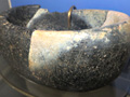
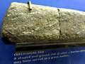
Steatite Cup, 1970 Elderberry Canyon Dig x5
|
The site owner makes no assertions as to ownership of any original copyrights to digitized images. However, these images are intended for Personal or Research use only. Any other kind of use, including but not limited to commercial or scholarly publication in any medium or format, public exhibition, or use online or in a web site, may be subject to additional restrictions including but not limited to the copyrights held by parties other than the site owner. USERS ARE SOLELY RESPONSIBLE for determining the existence of such rights and for obtaining any permissions and/or paying associated fees necessary for the proposed use.
