Page 7 - dort1948
P. 7

Page  2


                 easily aooessible  by  US  Highway  6,  aa  well  as  by

                 numerous  state  and  county  roads.  It  lies  30  m1lea
                 trom  the  Loa  Angeles  01v1o  Oenter.


                               This  report  deals  w1 th an  area  ot  approximately

                twenty-six  square  miles,  comprising  parts  of  the  Saugus,

                Newhall,  Sylmar  and  Humphries  quadrangles  mapped  by  the

                United  States  Geologioal  Survey.  It  la  essentially

                bounded  by  Bouquet,  Plaoerita,  Soledad,  and  Mint  Canyons.

                The  aettlements  ot  Saugus-Pardee,  Bonby,  Solamint,

                St.  Johns,  and  Forest  Park  are  included  within  these
                boundaries.


                                                                                      "

                                                                                     1


                                                                             o      ,o
                                                                               mile•
                                           US   101

                                            US    IOI-


                           ~ A re"  ma.pp ed

                           _ ,:_.,...,...-_-....~   Ventura.  l3o..oin
                           /


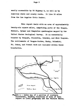
                   Pigure  1  - Index map  ot a  portion  of  southern
                       Oal1torn1a,  showing  relations  ot  area  ot  th1a
                       repc,pt  to  local  geography  and  the  Ventura  Basin.
   2   3   4   5   6   7   8   9   10   11   12