
Page 14 - lw3356
P. 14
bridge over Castaic Creek just west design and of these four, only one, course somewhere near the center of
of the junction of Route 79 with built about 1925, was damaged. The the cones and the banks of the chan-
Route 4 were taken out by the high balance of the Santa Ana bridges nels are usually somewhat higher
water. This bridge will probably be were built prior to the inclusion of than the adjacent slopes of the cones.
replaced with a modern type bridge the routes in the State system. Of As a result of this condition, the
at a slightly higher grade. the latter group, five bridges were lost streams at flood stages overflow the
or seriously damaged. banks and spread out over the fl.at
SP ANS DESTROYED
In the . vicinity of San Bernardino slopes of the cones readily forming
Three spans of the concrete bridge and westerly toward Upland and new channels in the relatively loose
across Malibu Lagoon, on the Coast Pomona, many streams such as the and unstable silt deposit.
Highway above Santa Monica, were Santa Ana River, Warm Creek, Lytle
lost when heavy scour caused settle- Creek, Cucamonga Wash and San DEBRIS CONES
ment of two piers. This bridge was Antonio Creek, overflowed their Boulders, drift or other obstruc-
built by the county about 1923 and banks and in several places estab- tions particularly near the upper
later widened to a forty foot roadway lished new channels across the high- ends of the cones may easily deflect
by the State. ways. Damage by these streams oc- the flow to one side or the other and
Further south on the same route, curred particularly on Routes 9, 26 change the entire course of the
the reinforced concrete bridge near and 19. New structures, bridge and streams. It was, these changing con-
the mouth of the Santa Ana River culvert extensions and extensive pro- · ditions and locations of streams which
was damaged in a similar manner. tection and control work will be caused so much damage to east and
The overflow 'from this river also necessary to avoid a repetition of the west highway Routes 9, 26 and 19
washed out a short section of fill a losses. which cross several such debris cones
few hundred feet north of the bridge. It will be noted that this area lies between P omona and San Bernar-
Near the junction of Route 60 with adjacent to the foothills of the San dino.
Route 2 at Serra, San Juan Creek Bernardino Mountains. The sparse A similar condition occurred in the
crosses State Routes 64, 2 and 60. forest cover of the mountains permits Big Tujunga Wash. Route 9 crosses
One steel stringer span of a timber rapid run-off of rain falling on them this stream between Pasadena and
and steel bridge on Route 64 was lost. with resultant flash fl.o_ods and high San Fernando. • Bridges ,were , pro-
On Route 2 a comparatively new con- velocities in the canyons. All these vided for both the north and south
crete bridge was not injured except conditions are conducive to heavy channels, both of which seemed to be
that scouring of approach fills re- scour on the steep slopes and the silt well defined. However, during the
sulted in some loss of slope pavement. and debris is carried to the valleys March storm, overflow from the south
On Route 60 no damage occurred to and plains at the foot of hills where channel spread out and caused con-
the new concrete bridge but addi- the flatter gradients of the streams siderable damage to the highway be-
tional length of bridge may be ad- permit silting. These silt deposits tween the bridges. The bridges were
visable to permit more immediate form debris cones which in this sec- not seriously damaged but approach
run-off. tion have built up over a long period fills and protection work were par-
Of some fourteen State highway of time to sizable proportions and tially destroyed.
crossings of the Santa Ana River only cover areas of many square miles. Due largely to the heavy flow in
four are of modern steel or concrete The streams ordinarily follow a the Tujunga, the Los Angeles River
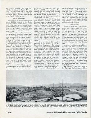
Sespe Creek swollen out of its banks by t ri butar ies in a high mountain area of Ventura County cut a wide swath of damage
as it swept across State H ighway 79 near Fillmore. A co unty- built timber and concrete bridge and a paralleling railroad struc -
ture were washed away. A large section of highway w as obliterated but a detour road shown at right was quickly built and
opened. I
[Twelve] (April 193 8) California Highways and Public Works