
Page 11 - ssmtmp2_initialstudy20171102
P. 11
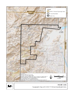
LEGEND
                                              SIMI VALLEY EAST                      USGS 7.5-Minute Quadrangle Index
                                                CALABASAS                           County Boundaries

                                                                                    Study Area


                         High Point
                        Elev. 1,877 Ft.       High Point
                                             Elev. 1,846 Ft.
                                                                                                    Low Point
                                                                                                   Elev. 896 Ft.

                                                Phase II.b


                                                                                                              CANOGA PARK


                                    SOURCES:
                                    Basemap: ESRI USGS Topo Map.
                                    Counties: US Census Bureau 2014.                      0      0.25    0.5
                                    Elevation Points: Provided by John Diaz, County of Los Angeles Dept. of  Miles
                                    Parks and Recreation. DEM data created by Infotech Enterprises, LLP -
                                    QC by Dewberry, project managed LAR-IAC.                   1:30,000
                                    Quadrangle Index: US Geological Survey 2010.
                                    Study Area: LA County Dept of Parks and Recreation (LACO-DPR) 2017.
                                                                  Q:\Projects\1020\1020-097\ArcProjects\MND\Sept2017_Draft_MND\Project Description\Fig1.4-3_TopoMap_IIb.mxd

                                                                                                FIGURE 1.4-3b
                                                       Topographic Map with USGS 7.5 Minute Quadrangle Index