
Page 14 - ssmtmp2_initialstudy20171102
P. 14
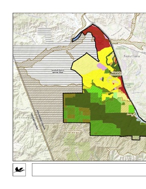
LEGEND
Significant Ecological Area (SEA) Land Use Plan CG - General Commercial
Study Area - Phase II.a RL1 - Rural Land 1 CM - Major Commercial
County Boundaries RL2 - Rural Land 2 IL - Light Industrial
RL5 - Rural Land 5 IO - Industrial Office
RL10 - Rural Land 10 P - Public and Semi-Public
RL20 - Rural Land 20 OS-BLM - Bureau of Land Management
H2 - Residential 2 OS-C - Conservation
H5 - Residential 5 OS-PR - Parks and Recreation
Santa Clara H18 - Residential 18 SP - Specific Plan
River SEA
H30 - Residential 30
Newhall Ranch
Specific Plan Valley Oaks
Savannah SEA
Santa Susana Mountains/
VENTURA COUNTY
LOS ANGELES COUNTY
Simi Hills SEA
SOURCES:
Basemap: ESRI World Topo Map.
Counties: United States Census Bureau 2014.
Land Use: LA County Enterprise GIS 2017, LA County DRP
2015.
SEAs: LA County Enterprise GIS 2015, LA County DRP 2015.
Study Area: LA County Dept of Parks and Recreation (LACO-
DPR) 2017.
0 1 2
Miles
1:70,000
Q:\Projects\1020\1020-097\ArcProjects\MND\Sept2017_Draft_MND\Project Description\1.6-2_LandUse_a_v2.mxd
FIGURE 1.6-2a
Los Angeles County Land Use Designations (Phase II.a)