
Page 5 - doi_preservationbrief36
P. 5
0" ......... ··
® ...... « ... .
® ..... -.•
~.M ...... « ....
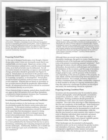
Figure 10: Traditional land uses are often the key to long term Figure 11: Landscape archeology is an important research tool that can
preservatIOn. Therefore, a knowledge of prior landscape management provIde locatIOn, dating and detail verification for landscape features. At
practIces IS essentwl as part of the research phase. Land use patterns were MontIcello, the estate of Thomas Jefferson in Charlottesville, Virginia,
ofte~ the result of t~adltlOnal actlVltles such as agriculture, fishing or archeologIcal research has employed both excavational and non-invasive
mlnll1g. In HanaleI, Hawall.for example, taro fields are important methods .. This has i~cluded aerial photography, soil resistivity, transect
because they reflect the continuIty of use of the land over time. (courtesy and stratified sampling and photogrammetric recording. As illustrated
Land and Community Associates) In the plan above, fence post spacing and alignment can be confirmed
3
with a transect trenching technique. (courtesy Thomas Jefferson
Memorial Foundation)
Preparing Period Plans Although there are several ways to inventory and
document a landscape, the goal is to create a baseline from
In the case of designed landscapes, even though a historic
a ~etailed record of the landscape and its features as they
design plan exists, it does not necessarily mean that it was
eXIst at the present (considering seasonal variations)? Each
realized fully, or even in part. Based on a review of the landscape inventory should address issues of boundary
archival resources outlined above, and the extant landscape
today, an as-built period plan may be delineated. For all deli~ea.tior:' docume~tation methodologies and techniques,
the hmitahons of the mventory, and the scope of inventory
successive t.enures of ownership, occupancy and landscape efforts. These are most often influenced by the timetable,
change, perIOd plans should be generated (see Figure 13, budget, project scope, and the purpose of the inventory
page 6). Period plans can document to the greatest extent and, deper:ding on the physical qualities of the property, its
possible th~ historic appearance during a particular period scale, detml, and the interrelationship between natural and
of ownershIp, occupancy, or development. Period plans cultural resources. For example, inventory objectives to
should be based on primary archival sources and should develop a treatment plan may differ considerably compared
avoid conjecture. Features that are based on secondary or to those needed to develop an ongoing maintenance plan.
less accurate sources should be graphically differentiated. Once the criteria for a landscape inventory are developed
Ideally, all referenced archival sources should be annotated and tested, the methodology should be explained.
and footnoted directly on period plans.
Where historical data is missing, period plans should reflect Preparing Existing Condition Plans
any gaps in the CLR narrative text and these limitations Inv~ntory and documentation may be recorded in plans,
considered in future treatment decisions (See Treatments sectlOns, photographs, aerial photographs, axonometric
for Cultural Landscapes on page 13.)
perspectives, narratives, video-or any combination of
techniques. Existing conditions should generally be
Inventorying and Documenting Existing Conditions documented to scale, drawn by hand or generated by
computer. The scale of the drawings is often determined by
Both physical evidence in the landscape and historic
documentation guide the historic preservation plan and the size and complexity of the landscape. Some landscapes
treatments. To document existing conditions, intensive may require documentation at more than one scale. For
field investigation and reconnaissance should be conducted example, a large estate may be documented at a small scale
at the same time that documentary research is being to depict its spatial and visual relationships, while the
discrete .area aro~nd .a~ estate mansion may require a larger
gathered. Information should be exchanged among
scale to Illustrate mdividual plant materials, pavement
preservation professionals, historians, technicians, local
pat~erns and other details. The same may apply to an
residents, managers and visitors.
entire rural historic district and a fenced vegetable garden
To assist in the survey process, National Register Bulletins contained within. (See Figures 14-15, page 8).
have been published by the National Park Service to aid in
When landscapes are documented in photographs,
i~enti~ying, nominating and evaluating designed and rural
histonc landscapes. Additionally, Bulletins are available for registration points can be set to indicate the precise location
and orientation of features. Registration points should
specific land.scape types such as battlefields, mining sites,
and cemetenes. 6 correspond to significant forms, features and spatial
relationships within the landscape and its surrounds (see
5