
Page 6 - doi_preservationbrief36
P. 6
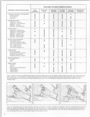
DEGREE OF DOCUMENTATION
            HISTORIC LANDSCAPE FEATURES        SITE      MANNING      HISTORIC    LETTERS     1955-1993   SECONDARY
                                            EVIDENCE       PLAN       PHOTOS      1914-1946   RECORDS     SOURCES
                                                ...                                  ...
            NATURAL SYSTEMS/TOPOGRAPHY                       ...         ...                     ...          ?
               Bedrock (Quarry)                 •            •           •           •
               Land Contour                     •            •           •           •           •
               Rockwork                         •            •           •           •           •
            WATER FEATURES                      ...          ...         ...         ...         ...          ?
               Alignment-Cascade                •                        •           •           •
               Alignment-Pools & Streams        •            •           •           •           •
               Materials-Cascade                •                        •           •           •
               Materials-Pools & Streams        •                        •           •           •
            CIRCULATION                         ...          ...         ...         ...         ...          ?
               Alignment-Upland Area                         •           •                       •
               Alignment-Perimeter Paths        •            •           •           •           •
               Alignment-Internal Paths                      •           •                       •
               Materials-Upland Area                         •           •                       •
               Materials-Perimeter Paths        •            •           •           •
               Materials-Internal Paths                      •           •           •           •
            SPATIAL RELATIONSHIPS               ...          ...         ...         ...         ...          ?
              Garden Site (Quarry)              •            •           •           •
              Viewshed (Cuyahoga Valley)        •                        •           •
               Vista over Garden from Terrace                            •           •
               Views within Garden                           •           •           •           •
              Views within Upland                            •           •           •
               Views from Croquet Lawn                       •           •
                                                ...          ...         ...
            VEGETATION                                                               ...         ...          ?
               Native Forest Trees              •            •           •           •           •
               Ornamental Shrubs in Garden      •                        •           •           •
               Groundcovers in Garden           •                        •           •           •
               Herbaceous Plants in Garden                               •           •           •
            SITE FURNISHINGS                    ...          ...         ...         ...         ...          ?
               Lanterns                         •                        •           •           •
              Seats                             •                        •           •
                                                ...          ...
            STRUCTURES                                                   ...         ...         ...          ?
              Torii Gate                        •                        •                       •
               Cistern                          •            •                       •           •
               Stone Wall Concealing Cistern    •                        •           •           •
               Lagon Bridges                                             •           •           •
               Umbrella House                                            •           •
               Trellis/Lattice                                           •           •


           Figure 12: This chart measures available documentation for character-defining features  in the Japanese Garden at Stan Hywet Hall, Akron, Ohio designed by
           Warren Manning.  Areas with little or no historic documentation are noted, thus identifying areas where future treatment options may be restricted.  As
           illustrated, restoration or reconstruction are viable alternatives based on the rich research findings.  (courtesy Stan Hywet Hall Foundation, Inc. and
           Doell and Doell)


          Figure 13:  Period plans show the evolution of Aspet, the home of Augustus St. Gaudens, Cornish, New Hampshire.  Plans were developed at two scales: first
          for the entire estate's development, and second for the core area around the house, studio and gardens.  For both, plans were generated for five time periods:
          1885-1903,1903-1907,1907-1926,1926-1965 and 1965-1992.  Illustrated above are the 1885-1903,1907-1926, and the 1926-1965 plans for  the core area.
          (courtesy National Park Service, North Atlantic Region and Pressley Associates)

       6