
Page 8 - doi_preservationbrief36
P. 8
XII
.
fEET: r. APPROXIMATELY 31"
.
METERS: 1: 4~
VII
VIII
IIICJTI: THE ANA OOCUNEHTlD USING AlJIIAI. I'ttOfO.
~ AND DIOfTIlEO..........a IrIClUOf:l,. 100'
I'IIGHT..Of.WAY ON EACH IlOl 01' IIIOCJ( CflUI(OIIITHl
~1IIOM1~THE'Nl«WAY. WHICMIV(JI
W ..... 'MTHlIT IN AIIlAS .... OND THII 1CIIJJrIIMIn',
COffTCIIJR ANO ~ DATA W .... TMIN HIOM
lW'OlQUICU: D.C. DlPMnelTOf~"'TICIH
.....,. 11" _ 200'1. MVIIO) ''',: ANO D.C. lOMAn
ANO TMRlC AlJIIAI.~""'" 1'I'...a.oICO
INC. n° _4O'1, 'I1 • ......,'IU.
lM(IIl WUIL ~ OIICfIU'NClEI 1IIlGND-
..aTHE ,AMW>,.,.~. Nl cw..: OU'ItTID.
c:c:IM'UDHIOMIfYlIW..~_I'UHI.
=.'_ ISTA" AT\AS liMO.!. ANO THE ,..
OM.V SlLICT WOlTATION _ OWIOUIl'" 'I'\.AHTtO'
..... TINAI. AND MATlJIIt TIIIUI - ll ~IIO IV
NAMf. ....110 ON ,1tUI """"". THEil! AIIl MOM
..oMilU.t.l TIIHI IN IIEAUTY THAN IHOWH IN 1I'lAN.
.. ~, ..... " "'''~E STATION fWATERGATE [lOCOfriI
0
'"'
0
III
~
~
"
...
~ I- ~ ~
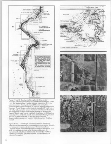
Figures 14 and 15: Existing conditions plans for large corridor
landscapes can employ a variety of documentation methodologies. For the
2 -1/2 mile Rock Creek and Potomac Parkway, Washington, D.C., the
Historic American Buildings Survey (HABS) used aerial photo-
grammetric photographs as the basis for digitized mapping and delineated
drawings. Overall documentation was done at a scale of 1" = 40' with a
100' either side geographic context. Contours were shown at 2' intervals,
tree canopy with trunk placement for specimen species, bridges (also
drawn in detail), roads, and the creek itself. In all, there are 36 drawings
measuring 34" x 44" for the project. These two sample drawings include
the index to plans (above) and an area of existing conditions
documentation (opposite top). (courtesy Historic American Buildings
Survey)
Figures 16 and 17: Landscapes cannot be inventoried in a vacuum.
Therefore, an understanding of its geographic context or setting should be
part of inventory process. At Rancho Los Alamitos, Long Beach,
California (middle and bottom opposite), a comparison between the 1936
aerial view with a present day aerial photograph illustrates the
encroachments and adjacent developments that will affect the future
treatment of visual and spatial relationships. (courtesy Rancho Los
Alamitos Foundation)
8