|
|
Ridge Route | Castaic
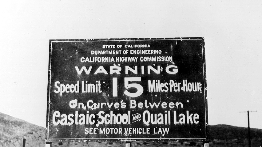
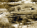
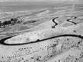
Click image to enlarge Warning sign, south end of the Ridge Route, Castaic, 1920s. Ridge Route historian Harrison Scott (2002) writes (pp. 72-74): "Due to the elevation and circuitous nature of the new highway, the speed limit was set at 15 miles per hour. The speed limit for heavier trucks with solid rubber tires was 12 miles per hour." "The Sheriff said: Woe to the man, woman or unlicensed child who tries to speed where there is to be no speeding — none at all, whatsoever ... I don't want to be killed myself up there and I'm not going to let anyone else take the chance." "Before the road was thrown open, the Automobile Club of Southern California was given only 24 hours' notice to post signs along the nwe highway. ... The Automobile Club erected approximately 150 metal road signs [by late October 1919]. People complained that there were more signs than trees. Ultimately some of the signs were removed and warning signs were erected at both the northern and southern terminals of the Ridge Route." "All of those warning signs were a testament to the 'never ending' twists and turns of the old road. ... In the 36 miles between Castaic and Gorman the road had 697 curves, which equalied 97 [complete] circles."
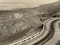
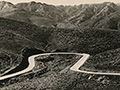
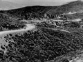
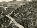
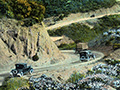
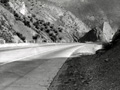
Ridge Route history by Jerry Reynolds: Ever since the days of Phineas Banning, General Beale and the Butterfield Overland stage, vehicles made their way out of Los Angeles, through San Francisquito Canyon, down the Grapevine Pass, and then into Bakersfield. The California Highway Commission was formed in 1911, and one of its first priorities was to build a simpler, more direct road through the La Liebre Mountains. That task fell to the man with the unlikely name of W. Lewis Clark. Frustrated in several attempts to locate an easy way across the stony barrier, Clark, at last, blazed a trail right over the top from the mouth of Castaic Canyon to Gorman. It was called the Ridge Route. After a year of toil, during which four-horse Fresno scrapers graded hilltops alongside chugging Caterpillar tractors to the tune of a staggering half-million dollars, the Tejon Route, as it was originally dubbed, opened to the motoring public late in November 1915. The Auto Club did a little calculating, finding that in the 36 miles between Castaic and Gorman, there were 642 curves that added up to 97 complete circles. It did cut 60 miles off the road, however. (Note: Some sources said 642 curves, others 697.) Even before construction started in 1914, an enterprising businessman by the name of Sam Parsons purchased an acre of land from W.H. Cook fronting the stake line, then threw up a general store that catered to the needs of the workers. Afterwards, "Sam's Place" became a mecca for truckers and the beginning of a new town called Castaic.[...] While the Ridge Route did not bring permanent residents (to the Santa Clarita Valley), for the most part it did cut down on travel time to the great markets of Los Angeles. One could journey to town and back in a single day — amazing! Then there was the increasing horde of gentlemen clad in long linen dusters with goggles, piloting their chugging, spitting vehicles with names such as Marmon "41," Winton "Six," or Packard ("Ask the man who owns one"). They, their womenfolk, and children might get hungry along the way or need gasoline or automobile repairs. So began a series of what might be called "tourist traps." [...] The next stop (after Newhall-Saugus) along the Ridge Route would have been Castaic, (and then) there was the Ridge Road Garage, The Tumble Inn, Reservoir Summit, and that splendid establishment in the wilderness known as Sandberg. Local rancher Herman Sandberg provided excellent, guaranteed-fresh steaks at his hotel. Slot machines could also be found there and, in a long, low building out back (known as "The Crib,") feminine companionship was available for weary truckers and lonely salesmen. [...] In 1933 Highway 99 was carved up the canyons, bypassing the 18-year-old Ridge Route, which was already antiquated.
HR2001: 9600 dpi jpeg. |
SEE ALSO:
Ridge Route Series
Story by Harrison Scott 2004
Auto on Ridge Route ~Late 1910s
1918-1930
1920s
Castaic Area ~1920s
Serpentine Drive x2
Ridge Route ~1930s
Grapevine Grade (Mult.)
Speed Warning 1920s
Graceful Turns ~1930s
4-26-1937
Film: Gorman to Grapveine, Winter 1939
|

The site owner makes no assertions as to ownership of any original copyrights to digitized images. However, these images are intended for Personal or Research use only. Any other kind of use, including but not limited to commercial or scholarly publication in any medium or format, public exhibition, or use online or in a web site, may be subject to additional restrictions including but not limited to the copyrights held by parties other than the site owner. USERS ARE SOLELY RESPONSIBLE for determining the existence of such rights and for obtaining any permissions and/or paying associated fees necessary for the proposed use.
