|
|
Chapter 1: Geology.
Land of the Sunny Slopes: A History of Vasquez Rocks.
Master's Thesis, California State University, Northridge, 2016.
|
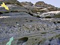
Abstract. The Vasquez Rocks are located in what is known as the Soledad Basin, which sits cradled to the south of the smaller Sierra Pelona Mountains, and to the west and north of the more well-known, larger San Gabriel Mountains. Soledad Canyon runs to the south of the park, Mint Canyon runs to the north, and Agua Dulce Canyon runs north to south right through the Vasquez Rocks area. The distinctive formations were formed through a relatively simple process, and the clues to its creation are still visible all around. Over the course of the past 25 million years (the most commonly agreed-upon age by geologists), vast amounts of sediment (sand, soil, rocks, and organic materials) were brought downward into the Soledad Basin by events such as rains, flooding, landslides, wind, and earthquakes from the surrounding San Gabriel and Sierra Pelona Mountains. As these materials were deposited on the basin's floor, they would settle flat on the ground surface, and as years passed, new deposits covered the older ones, eventually placing them under tremendous amounts of pressure. With this pressure, the deeper layers lithified, turning into sandstone. As these layers were deposited during separate periods by different events, they have created a physical record of the weather and atmosphere during the periods in which they were created. Because the layers are made of inorganic materials, they cannot be dated using technology such as radiocarbon dating, but we are able to see which events happened before or after others, allowing us to construct a timeline for how the layers were formed. Dry, stable periods made for relatively uneventful (or nonexistent) layers in the sandstone, while extremely dramatic years, such as those with heavy floods or landslides, resulted in the opposite: thicker, more complex and dynamic layers, which can contain various other minerals or even larger pieces of existing rocks. The Vasquez Rocks area is located in an extremely geologically active area in terms of earthquake activity. The famous San Andreas fault, which divides the massive North American and Pacific tectonic plates runs through the towns of Acton and Palmdale, only miles from the Vasquez Rocks area. An offshoot of the San Andreas, the Elkhorn Fault, runs right through the park and has resulted in a large amount of movement over millions of years. Extreme pressure and movement resulted in the uplift of the once-flat sandstone, cause it to rise in certain areas of angles over 50 degrees. Today, the rocks largely point toward the northeast, and it is estimated by geologists that parts of the formation also go down approximately 22,000 feet, or around 4 miles. In the park, there are three main formations to know: Lower Vasquez Formation is the oldest, with geologists estimating an age of approximately 25.6 to 23.6 million years old, and a thickness of approximately 1,300 meters or 4,200 feet. The Vasquez Formation lays on top of the Lower Vasquez Formation. It is approximately 5,800 meters (or 19,000 feet) in thickness and is approximately 20 million years old. The newest formation visible in Vasquez Rocks is the Mint Canyon Formation, which is approximately 1,550 meters, or 5,000 feet, in thickness, and 10-16 million years old. Exposure to the elements causes the sandstone layers in each formation to erode, with their degree of hardness dictating the rate and severity of this erosion. What results is a layered effect, with some sharply-angled rocks rising prominently toward the sky. As with anything of such an ancient age, the Rocks have persevered but are always changing. Exposure to the elements breaks and shapes the rocks, which complete its circle and eventually becomes sand once again. Through erosion, the rocks become smaller as centuries pass, and they become rounded and smoothed from wind and rain. It is interesting to think about what the rocks looked like 500, 5,000 and 5,000,000 years ago, and what they will look like in the distant future.
|
1. Geology
1. Natural History
2. Native People & European Arrival
3. American Pioneers
4. Private Ownership Era
5. Early Roadways & Tourism
6. Film History
7. Becoming a Park
|


The site owner makes no assertions as to ownership of any original copyrights to digitized images. However, these images are intended for Personal or Research use only. Any other kind of use, including but not limited to commercial or scholarly publication in any medium or format, public exhibition, or use online or in a web site, may be subject to additional restrictions including but not limited to the copyrights held by parties other than the site owner. USERS ARE SOLELY RESPONSIBLE for determining the existence of such rights and for obtaining any permissions and/or paying associated fees necessary for the proposed use.
