|
|
Runner Bill Would Mark Ridge Route
By Margie Anne Clark
Signal Staff Writer | Tuesday, July 24, 2001
|
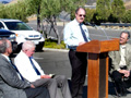
Assemblyman George Runner introduced legislation Friday to enable the Ridge Route Preservation Organization to place a monument at Castaic Junction, commemorating the historic highway. Assembly Concurrent Resolution 98 is expected to have its first committee hearing in August. If passed, the bill would instruct Caltrans to issue a permit for a monument at Interstate 5 and state Route 126, when the interchange is reconfigured in the next three years. "The Ridge Route is historic in that it opened up travel between southern and northern California," said Runner, R-Lancaster. "Without this road, California very well would have become two separate states. "Certainly, a monument would serve as a good reminder of the historical significance of what helped to develop California into the economic state that is today." Runner said he is optimistic the bill will receive a stamp of approval. "Given the historical value of the road, I think it will have a good chance of being approved," he said. In 1915, a narrow, curving stretch of highway known as the Ridge Route traversed the threshold of destiny by uniting a state that would become the land of the golden dreams. The 30-mile Ridge Route is a 20-foot-wide roadway that was carved out using horse-drawn dirt scrapers that zigzagged across the ridges of the western San Gabriel Mountains. The road was named for the way it followed the ridge line of the mountains. Paved in 1919, the Ridge Route highway, officially named the Castaic-Tejon Route, became the first direct road connecting Los Angeles and Bakersfield. Often referred to as the original Grapevine route, the nickname stems from the fact that early wagoners had to hack their way through thick patches of cimarron grapevines that inhabited "La Canada de Las Uvas," or Canyon of the Grapes. In 1933, the state opened the Ridge Route Alternate, a three-lane road with fewer curves that would eventually be designated California 99. This alternate was widened to four lanes in the 1950s, then realigned and rebuilt in the 1960s as a high-speed interstate. The original Ridge Route was all but abandoned. Nearly a century later, through the efforts of Harrison Scott, president of the Ridge Route Preservation Organization, and a few of his associates, motorists can still take the winding, rugged drive and re-live a part of California's heritage. Six years of research and perseverance culminated in 1997 when Scott accomplished his goal of qualifying 17.6 miles of the Ridge Route for the National Register of Historic Places. A Torrance resident, Scott became interested in the Ridge Route after driving the road known for its 697 curves, which make the equivalent of 110 complete circles as they cross the mountains. His son remarked that it must have been a tough climb back in the early 1900s when a Model T Ford was the transportation of the day. "I wasn't a member of any historical societies, but I though that this road had to be saved," said the retired Pacific Bell engineer. Poring through reams of paperwork, Scott found that while there was once a proposal to close the road and turn it into a bike path, the plan was abandoned and went into limbo. To help raise awareness of the need to preserve the historic engineering marvel, Scott enlisted the aid of the Santa Clarita Valley Historical Society to bring the idea of a monument to the attention of the local assemblyman. "Mr. Runner has consistently been at the forefront of saving our valley's history," said historical society President Leon Worden. "Hopefully this new monument will be one of many ways the SCV Historical Society and the Ridge Route Preservation Organization can work together to ensure that the historic road will be remembered. "Harrison Scott is a star in the effort to preserve this piece of history that is important not only to the Santa Clarita Valley but to all of Southern California," he said. The plan calls for the local chapter of the fraternal organization E Clampus Vitus to install the commemorative plaque and monument at no cost to the public. E Clampus Vitus grew out of the state's Gold Rush era with a group of miners who would work together to support each other in time of need. The group evolved into an organization dedicated to erecting monuments for historic places. Scott said he has high hopes for preserving the old Ridge Route. "I hope it the bill passes. Having a monument will help to raise awareness about the road. I would like to see the road remain open for future generations to enjoy."
©2001 THE SIGNAL • USED BY PERMISSION • ALL RIGHTS RESERVED. |
• Legislation 2001
Dedication 2008 x3
|


The site owner makes no assertions as to ownership of any original copyrights to digitized images. However, these images are intended for Personal or Research use only. Any other kind of use, including but not limited to commercial or scholarly publication in any medium or format, public exhibition, or use online or in a web site, may be subject to additional restrictions including but not limited to the copyrights held by parties other than the site owner. USERS ARE SOLELY RESPONSIBLE for determining the existence of such rights and for obtaining any permissions and/or paying associated fees necessary for the proposed use.
