|
|


Click image to enlarge
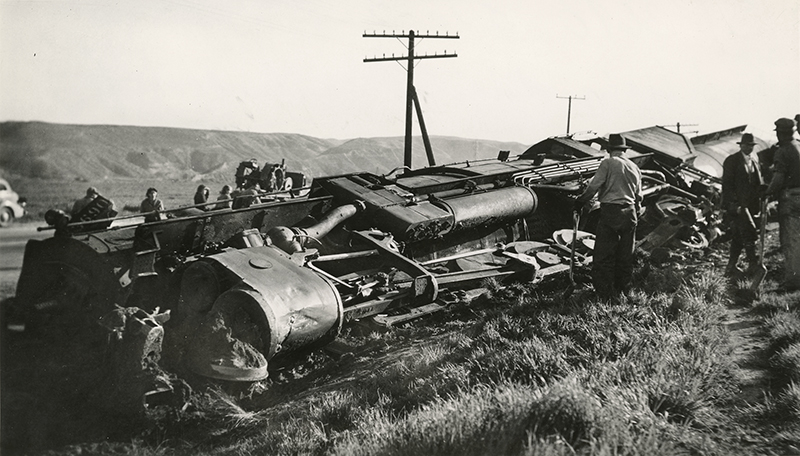
March 25, 1938 (Photo March 26) — Collateral damage from the Great Flood of March 2, 1938: A Southern Pacific locomotive rests on its side after it hit an open switch outside of Saugus. According to the L.A. Times (below), it was returning from a location where a work crew had been repairing flood damage. According to Union Pacific engineer Jeff Hosford (pers. comm. 2022), the derailment occured at the east switch (geographically west) of Honby siding, at the present-day intersection of Soledad Canyon Road and Ruether Avenue. The camera is looking north; Golden Valley Road now goes up the canyon just left of the telegraph pole. SP Engine No. 3690 was a big Class F-4 locomotive with a 2-10-2 wheel configuration. It was one of 70 such locomotives built by Baldwin from 1917 to 1925. Photo: 3¼x5½ inches, probably a copy print.
Switch Derails Espee Engine.
Los Angeles Times | Saturday, March 26, 1938.
Striking an open switch three miles north of Saugus last night, the engine of a work train returning from the north, where a crew of workmen had been repairing flood damages, was derailed and two men were injured slightly. The injured men were Edward Niday, fireman, of Saugus, and Earl Whitseldt, 43 years of age, of 364½ Thorpe street, Los Angeles, a brakeman. Both men were taken to the Newhall Hospital. Southern Pacific engineers said that the derailed engine would not delay passenger train traffic and that the line would be cleared within three hours.
News story courtesy of Tricia Lemon Putnam.
About the Great Flood. Surpassing the St. Francis Flood of 1928 in scope — if not in deaths — the Great Flood (aka Los Angeles Flood) of 1938 hit the greater Los Angeles area hardest overnight on March 1-2. By the time the water receded, 5,601 buildings had been destroyed and 113 to 115 Southland residents were killed. Considered a 50-year flood, it started Feb. 27, 1938, when a storm system moved in from the Pacific Ocean and hit the San Gabriel Mountains. The region was soaked with continual rainfall that caused only routine flooding until a second storm came on the heels of the first. Driven by gale-force winds, it hit March 1 at about 8:45 p.m., dumping 10 inches of rain in the lowlands and at least 32 inches in the mountains. Almost every vacation resort in the San Gabriels washed away; most were never rebuilt (see Robinson 1977). The Santa Clarita Valley wasn't spared. The Santa Clara River overflowed. Roads and bridges were wiped out and ranch buildings situated along the riverbank floated away. (Note to current residents: The Santa Clara River might look dry most of the year, but watch out when it rains. It's prone to flash flooding. Stay away.) As hard as Los Angeles County got hit, Orange and Riverside counties actually sustained more damage because they lacked the kind of flood-control system L.A. had with the Santa Ana River system. (The Santa Ana, Los Angeles and San Gabriel rivers overflowed, too.) But Los Angeles was far more populated; Orange and Riverside counties were largely agricultural. In response to the 1938 flood, Congress passed the Flood Control Act of 1941, which authorized the U.S. Army Corps of Engineers to channelize the Los Angeles River and parts of the Santa Ana. And that's why the L.A. River is a concrete flood-control channel instead of the wild-flowing river it once was. — Leon Worden 2013
LW3067: 9600 dpi jpeg from original photograph purchased 2017 by Leon Worden.
|
The site owner makes no assertions as to ownership of any original copyrights to digitized images. However, these images are intended for Personal or Research use only. Any other kind of use, including but not limited to commercial or scholarly publication in any medium or format, public exhibition, or use online or in a web site, may be subject to additional restrictions including but not limited to the copyrights held by parties other than the site owner. USERS ARE SOLELY RESPONSIBLE for determining the existence of such rights and for obtaining any permissions and/or paying associated fees necessary for the proposed use.


