|
|
History of Downtown Newhall.
Originally published as Mining Camps of the Soledad, Part III.
By Arthur B. Perkins
Historical Society of Southern California Quarterly, Vol. 40 No. 4 | December 1958
In 1886, the railroad started its long discussed branch line down the Santa Clarita Valley to Ventura, from a point "just north of the cattle pens" at Newhall, close to Ninth Street. At that time, there was an old adobe residence at about Eleventh and Chestnut Streets. It was feared the vibration from the trains would disintegrate the mud bricks. To avoid argument, the railroad company thought twice. Newhall town lots were about sold out and the town was still existent. Possibly putting a railroad junction point, originally planned for Newhall, by the original townsite near Soledad Canyon's mouth would float a second townsite. So the brand new railroad, starting from today's Saugus, was open to traffic by February 8th, 1887. It reached Ventura May 18th, Carpinteria July first, and Santa Barbara August 19th. There was a not too severe earthquake. The adobe responsible for the re-routing of the railroad branch collapsed. The Ventura Stage lines also ended. The year of 1887 was disastrous for the little mining town.[a] In October, the Southern Hotel went up in flames. It was never rebuilt. Shortly afterwards the Grammar School, then taught by George Larkey, burned. The corporation that had succeeded the late Mr. Newhall may not have been too well sold on their Los Angeles County lands. They sold nothing from the "lower ranch" by Ventura County and the Camulos ranch. That was already highly cultivated. Apparently they welcomed sales prospects from the easterly end of their lands, farthest from the flow of the Santa Clara river. St. John's Subdivision In 1886, "Colonization" was very popular. (It is called "subdividing" today.) Anaheim was a successful colony of German artisans turned vineyardists. Whittier was a "colonization" of Quakers. Lompoc and Compton were Prohibitionist colonies. The Good Templars were then a virile organization, a popular catch-all for folks with a trend to a radical outlet. Governor John P. St. John, of Kansas, was then the national Prohibitionist leader. Jesse Yarnell was a successful land operator in Los Angeles, interested in the Porter Land Company at nearby San Fernando, and an ardent Prohibitionist. George B. Katzenstein was a capitalist of Sacramento. The trio dealt with the Newhall Land and Farming Co. for purchase and subdivision of acreage lying, very roughly, between Saugus and the southerly extremities of the ranch, some ten thousand acres in extent. This was for the purpose of promoting a Prohibitionist colony. It was mapped in 1887 as "St. John's Subdivision." One clause in the tract deeds is "that no distilled or alcoholic liquors, or malt, beer, intoxicating liquors whatsoever shall be manufactured, sold, or offered for sale, or kept in storage, made or used as a beverage upon the premises hereby or any part thereof, buy party of the second part, or any person holding under him."[1] The deed being subject to enforcement of this clause, it may reasonably be assumed the subdividers planned their colony primarily for purity.
To assure success of the project, in 1889, St. John sent west as "Superintendent of the St. John subdivision of the San Francisco Rancho," Henry Clay Needham. Needham has [sic] been educated at Hamilton College, Elizabethtown, Kentucky. He had taught school, prior to acquiring experience in selling land as a Kansas "Boomer," also in raising livestock and general farming. He had served as mayor of Arcadia, Kansas, where he had a successful lumber and hardware business.[2] Needham was very active within the Prohibitionist circles, establishing contacts with the movement in Los Angeles. He also promoted a local Good Templar Lodge. Their hall stood on Pine Street. One of Mr. Needham's first Newhall land sales was to a fellow Arcadian, John W. Buchert, first to re-subdivide under the St. John's tract, also first extension of the townsite. The next group of Newhall street names came straight from Kansas, being Kansas, Arcadia, Oak and Hill Streets. There were only occasional sales of isolated five or ten acre parcels in the St. John Tract. The Boom of the Eighties had busted. At Newhall, things were worse. The railroad had started a competitive town three miles away. Beale's Cut was now a county road and a tough pull, even for mules. Railroads were not set up for the convenience of little mining camps. There was a twice-a-day stage to Pico and a once-a-day train north and south. Most of the homesteaders weren't losing. Part time work in the oil fields carried them through. The nearest lode mining was up in the hills, by Acton. Oil, only, was getting to be more and more. It is surprising how many local families, still resident in the township, came in the Eighteen Sixties or earlier. They include the Mitchells, Ruiz, Raggios, Jenkins, Carmichaels, Powells, Lyons, Mores[b], Cordovas, Suraccos[c], Delanos, Olmes, Giffords.
A side activity of the town was fruit drying. The Earl Fruit Company of Los Angeles, Fleming & Fontana of San Francisco and Visalia, and other similar operators, utilized the broad flat east of the tracks[d] for fruit drying. Even after mechanical dehydration had come into use in the dried fruit industry, it was not uncommon for fruit dryers to burn out or be stymied by machinery breakdowns. At those times, Newhall picked up a temporary payroll. One of those days when the entire flat was well covered by trays of cut and drying fruit, a "twister" (similar to the twister that deroofed the local ice plant[e] in 1955) came shooting down the valley. Trays and apricots, trays and apricots, rained heavily for some time.[3] At the drying sheds, the cutters were all Chinese. The foremen were Americans and they were instructed by the Chinese Tong leader, acting as Padrone, to fire employees every week or so. The leader got $1.00 per head for furnishing new employees.[4] In 1889 Needham opened his lumber yard and hardware store. It was across Market Street, facing Pine Street. The old store was later remodeled into an existing residential rental. About this time, Ed Pardee, one of the Pennsylvania oil men brought out by Schofield[f] about 1880, decided to make a change. He came down from Pico and started a livery barn in a shed adjacent to Smith's Blacksmith shop on the west side of Spruce Street, north of Market Street. Blacksmiths were mighty important people in the camps of those days. Drills had to be hand sharpened. Tools and repairs were both hand jobs, whether for mining, oil well drilling, or farming. If anything broke — and what didn't — you fixed it. If you couldn't fix it, you just kept on walking.
The Newhall Land and Farming Company had apparently crossed off the Upper Ranch[g] from any future plans when they contracted its acreage sale with the St. John group. H.M. Newhall's Hotel, his school house, and many of his other buildings had burned. The corporation held no sentimental attachment to anything remaining in the little village. The working stock, implements, all of the equipment used in working the Upper Ranch were sold off. Even Mr. Newhall's favorite Spanish mules were sold. Ed Pardee bought them and shortly afterwards built the Pardee Livery Stables on the northeast corner of Market and Spruce. Pardee also acquired the second "Southern Hotel." Pardee probably didn't particularly want that but he had loaned a Mr. Louden the money necessarily to remodel the old hotel harness shed into a small hotel. Taking over the building was the only way he could get any of his money back. In 1890, John Haskell, a pioneer, bought the Haskell Canyon ranch. This same year, the Lewmans came to town, attracted by the stories of Ratsburg. They later took up a ranch at San Martinez Chiquito Canyon. Since the burning of Newhall's gift Grammar School, the children had been attending a makeshift in one of the old board and batt shacks on Spruce Street, just north of today's 24313 San Fernando Road.[h] Replacement of the old school, on the original site, built to the original design, was opened this year. It would be Newhall's fourth grammar school building.[i]
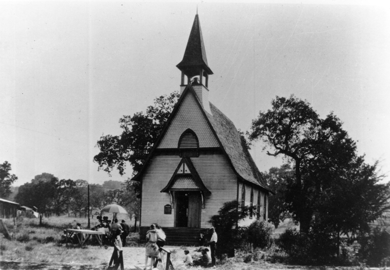
In 1879, a small group of local families started joining in the Sunday Meetings, originally held at the Southern Hotel. After the Southern burned, the group held together, meeting here and there, ending up in the new grammar school in 1888. August 4th, 1891, the Rev. W.D. Seward organized a "little church" class, of which the original families, the Drews, Gavins, Fields, and Giffords made up all but two of the charter members. In 1893, they again organized, this time as the Community Presbyterian Church, and with a few others, built their first church upon Newhall Avenue lots donated to them by Mrs. H.M. Newhall. Today's Community Presbyterian Church stands on the same site.[sup]<5> Surrey postoffice, at Saugus Junction, was established August 5th, 1891. In 1894, the first Castaic postoffice was opened September 15th, but was suspended the following August.[6] A school district had been organized at Castaic as of March 25th, 1889.[7]
The Nineties was a lugubrious decade. Practically nothing happened. A few land patents sifted through In 1897, covering the homesteads of Thomas B. Walker, Joseph Reynier, and G.H. Thompson in the Placeritas Canyon, William Bailey in the San Francisquito,and John Whitney in the Whitney Canyon.
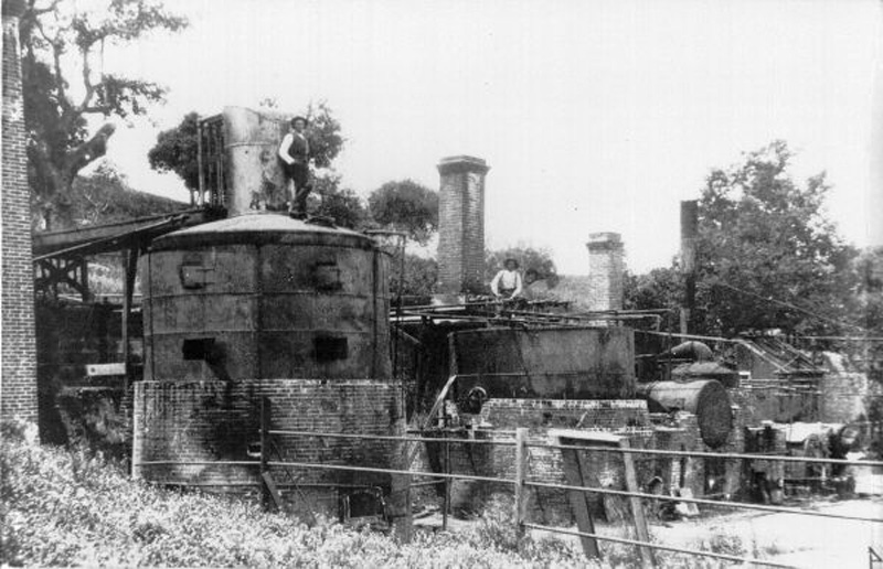
The federal census of 1900 listed 442 people in Newhall, apparently including the folks from Pico and the township canyons. The thermal springs at Lang and Newhall were becoming known, and the area was being recommended for invalids and general health conditions. Lang had erected a hotel by his sulphur springs, in the Soledad Canyon. A spa had also been promoted in the Ellesmere.[8][k] Less and less gold dust was coming from the placers. Fortunately, more was coming from oil. Industrial communities are built upon a base of cheap fuel. The local oil production made possible a Los Angeles fuel cost competitive with coal at $2.80 a ton. Prices of 1890!
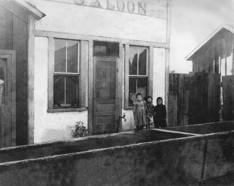
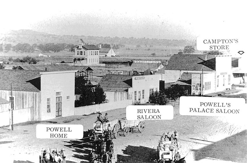
Newhall looked like even less than it had looked. The Southern Hotel was only a memory. The little local camp businesses were certainly no bigger. Water, or rather the lack of water, was a major problem. On the square, Nick Rivera's saloon drew water through a half-mile of ¾-inch pipe, meandering westerly to a spring, long dry, back of the Market Street spur. T.M. Frew had taken the blacksmith shop over from Sam Smith in 1900, as well as the J.O. Newhall home next door. He had about ¾ of a mile of 1-inch pipe running to a still active spring by the railroad tracks. The railroad got its water from wells by Saugus Junction, The Newhall Ranch had originally installed a 2-inch pipe line, running about a mile between the Southern Hotel and its outbuildings and a spring in the Railroad Canyon by the oil refinery. The ranch was broad-minded on the question of water. Local buildings without previously mentioned water sources could use water from the ranch line if, as, and when, the line happened to have surplus water in it, which was when no one else wanted water either.[l]
There was also a slight local problem of general business. Campton's and Gulley's Newhall stores were still running. Gold scales were still standard equipment in any place of business. There was a little payroll from Newhall ranch, a much better payroll from Pico. The square was quite like a deserted village excepting, possibly, Saturday nights when, by tradition, the wild wolves from Bitter Creek were supposed to howl.
Beale's Cut, the lifesaver of 1863, was now throttling the area. It had become a county road at expiration of the toll road franchise. Maintenance was not too good. If a wagon track ran to a known point, and you could see a half mile over the so-called road, it was considered in good condition. Worse, motor cars were now coming into use. The small farmsteads at the top of the Divide were eating off folks who over-estimated the capabilities of their motor cars and had to have mules to get over the Cut.
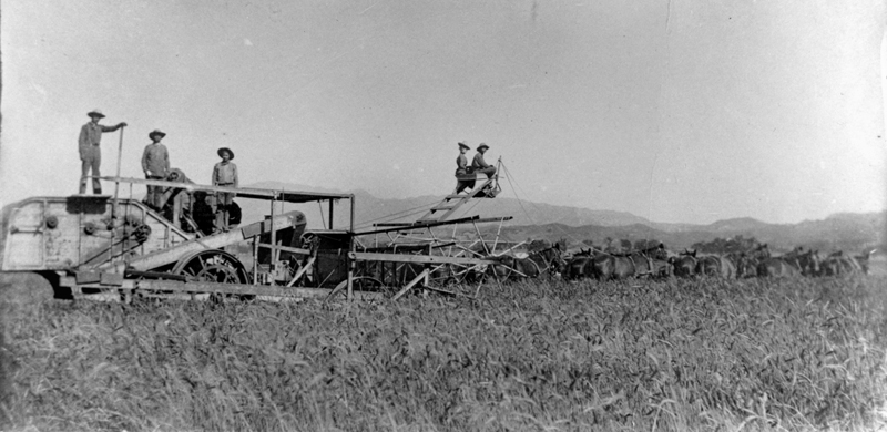
The century's first decade was a trial and tribulation until the City of Los Angeles commenced construction of the Los Angeles Aqueduct, with a resultant consistent demand for both labor and mules. For many years, each harvest season had seen the Swall Harvester brought down from the Antelope Valley, manned by Jake Swall and his three boys, Albert C., Henry, and Jake Jr. Harvesting was hard labor. Feeling that there must be some easier way of making a living, in 1904, Albert left the harvester crew and started a little meat market next to the Derrick Saloon[m] at the end of the square.
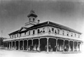
Successful in his first venture, he joined his cousin, James Gulley, in operation of the old Newhall General Merchandise Store at the other end of the square[n], in 1906, and shortly took over the Gulley interest. Next came landlord trouble. The landlord's estimate of the location on the square, based probably on no vacancies, differed widely from Swall's valuation. The only available building in town was the second Southern Hotel, now property of Ed Pardee, the constable and owner of most of the loose property off Main Street.[o] Swall paid Pardee $5,000 for Block 31. This was an undivided block, originally reserved by H.M. Newhall for his hotel and other enterprises. The building faced the back street (now San Fernando Road). Swall put his general store and postoffice on the ground floor, thus accommodating both hotel and store patrons.[9]
If that old register still existed (it burned, with the building, in 1917), it would have patterned the early history of the movies. Newhall was then a favorite location for films. Also, getting back to the City, during location, was something to be taken seriously. Everybody but Mary Pickford stayed at Swall's Hotel. On the register were Harry Carey, Cecil DeMille, Dustin Farnum. Those early "Greats," "The Virginians," and "The Light of the Eastern Star" were filmed on the Lasalle Ranch and the Sanborn Ranch. Mary Pickford and William S. Hart filmed "Rags" at the old Newhall Land and Farming Company's deserted warehouse on the square.[p] Charles Chaplin used the old Presbyterian Chapel as a favorite location up to the time it was moved and turned into a rental duplex, making room for the Community Presbyterian Church. Tom Mix lived in a little outbuilding of the Pardee home for years, filming hereabout. Incidentally, to this day, plenty of local folks supplement their annual incomes with "extra" checks. Before being wrecked or just naturally falling down, the old buildings on the square were assured of quite a little money each year as a location. As for the old chapel, it has been claimed that the location checks for films in some years exceeded the local contributions for the pastor.
The Newhall Land and Farming Company was very unhappy. The St. John subdivision had been a horrible flop. The Land Company was forced to take the land back. Even worse, a few parcels had been sold but they were scattered widely over the extensive ranch acreage south of the Pico Road[q], with the result that several thousand acres were not available for farming or grazing without tremendous fencing costs incurred for access to the sold parcels.
Their feelings were known to Mr. Needham who had been having a bad time due to losses in oil and mining ventures. Needham went over the hills to a fellow Prohibitionist, one H.W. Atwood, for financial backing, which he got. Needham and Atwood then contracted for the unsold ranch lands south of the Pico Road. The only money ever advanced by Atwood was the first payment to bind the contract.[10] The partnership land sales came fast enough to meet all necessary payments, including the cost of installation of Newhall's first water system. With the water mains, folks first moved into the Happy Valley.
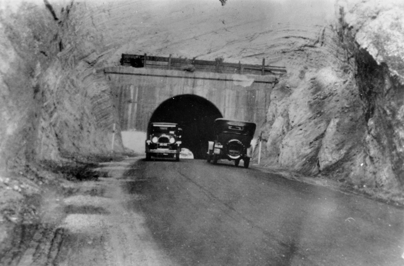
At about this time, around 1910, the County of Los Angeles listened to the shrieks of anguished motorists and replaced the facilities of Beale's Cut with the bored Newhall tunnel. Actually, the state had entered the picture. Need of through highways was beginning to be felt. The tunnel was only one item. The Highway Commission disliked the two fifty-foot jogs at the railroad depot right of way, on the existing road, but were unable to make arrangements with the necessary property owners to eliminate the jogs.
Aware of the disagreement and wanting the highway frontage as a business facility, Swall went to Ed Pardee, T.M. Frew, and other property owners facing the back street (San Fernando Road of today), made up a purse, bought fee title to Block Nine of the townsite at Tenth Street[r], and told the State Highway Commission to run the right of way through the block, as they might wish, at no cost to the state, which re-routed their proposed improvements. Instead of a highway on Railroad Avenue (Main Street), the road improvements went down the despised back street, curving through Block Nine well beyond the disputed original routing.[11]
Things were really changing. In 1908, Saugus had organized its own school district. By 1913, local growth necessitated a school district at Mint Canyon, superinduced by the Mint Canyon road which had pulled traffic, and resultant settlers, up the new routing.[12] General traffic conditions had been greatly improved when Beale's Cut was abandoned for the new highway Newhall tunnel in 1910. The local grammar school suffered from the passage of the years. On the west side, the two-story structure was propped up close to plumb by long timbers, a glance at which would bring up questions. In 1911, Buchert filed a re-subdivision of Lot 16, of St. John's subdivision, setting aside Lots 1, 2, 13 and 14 for school purposes. The new building came into use about 1914.[s]
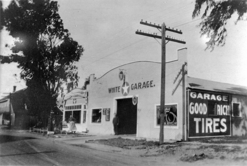
Moving from the square started about 1913.[t] Emil Chaix then picked up the Derrick saloon and shoved it over to the southwest corner of San Fernando road, Spruce and Eighth Streets.[13] Charles Conrad built a new dancehall in 1914, on the new road, just across from the present Ford garage.[u] It was a social center for a decade — every Saturday night. The payroll at the Sterling Borax Works in Tick Canyon, off Soledad, inspired homesteading thereabout.
On the new highway, Swall struck again, building his two-story brick hotel building just across from his second Southern Hotel, which unfortunately burned a little later, the heat being so great that the windows in Swall's Hotel across the street broke whenever water hit them.[v]
The old mining camp couldn't take this sort of punishment. In fact, there was practically no more mining. The bloom was off the rose at Pico. There was no hope excepting traffic, and that had been definitely diverted. Main Street, the square, Railroad Avenue, were deserted.[w] Any buildings on the square capable of withstanding vibration were skidded backwards on the "back street" frontage. The warehouses were razed for salvage.[x] By 1920, nothing remained in or of old Newhall. Starting afresh on the new highway, the town of Newhall was already sprouting pin feathers, preparing for flights in a not too distant future.
Debits and Credits
In turning the calendar back, help is always necessary. The courtesies received from the Bancroft Library, the Los Angeles County Library, and the Los Angeles Public Library are acknowledged. Without those courtesies, there would have been either great gaps or greater errors than occur.
Old-timers, Mrs. H.B. Russell, Mrs. Mabel Taylor, Mr. I.C. Gordon, the late Mrs. Jack Taylor, and Mrs. Celina Chaix, have been very helpful. The first two have been especially kind and forgiving. It is not practicable to list the individuals who have, in one way or another, co-operated through information, or original pictures of a past day.
My wife, Marguerite, has been most forebearing [sic] and patient with the foibles of a hobbyist. Besides that, she did much of the original research on the Soledad Mining Camp, and has patiently read for many days in many libraries that this attempt to give a solid documented background of a "day that is gone," might come to pass.
[Perkins'] Notes.
1. Records of Los Angeles County, Book of Deeds, p. 119.
2. "Illustrated History of Los Angeles County," (Lewis Publishing Co., Chicago, 1889) p. 575.
3. Informant, Mrs. H.B. Russell (née Pearl Pardee).
4. Informant, the late Mr. Lou Ledger.
5. Informant, Mrs. Mabel Gifford Taylor.
6. Postoffice Department archives.
7. Records of the Los Angeles County Board of Education.
8. "California of the South," (Lindley & Widney, New York, 1896) pp. 132, 185.
9. Informant, the late Albert C. Swall.
10. Informant, the late H. Clay Needham.
11. Informant, the late Albert C. Swall.
12. Records of the Los Angeles County Board of Education.
13. Informant, Mrs. Selina Chaix.
Webmaster's Notes.
a. Throughout, when Perkins refers to "the (little) mining town" or "local camp" or "old mining camp," he's discussing the Newhall townsite that was established in 1878 — essentially the current Old Town Newhall.
b. Commonly spelled Moore.
c. Commonly spelled Suraco. They might have arrived a bit later, in 1874, when they purchased a home and ranch in Bouquet Canyon.
d. The area between the present-day Newhall Community Center and the ridge to the east of it.
e. Newhall Ice Co. on 5th Street.
f. (sp) Scofield.
g. The "Upper Ranch" would be downtown Newhall and environs.
h. Shortly before Perkins wrote this piece, Spruce Street's name was changed to San Fernando Road. In 2007 this section of the road changed again, to Main Street. 24313 is on the west side of the street between 8th and Market.
i. Today, the 1890 school is considered Newhall's second schoolhouse. Perhaps Perkins is counting earlier private homes that doubled as schools. Like Newhall's first dedicated school building (1879), which burned down in 1890, its 1890 replacement it was a two-story structure of roughly the same size but with a different configuration, particularly in the placement of the bell tower.
j. It should be noted that the church building that existed in 1958 was razed after the 1971 earthquake, and a third church building was erected on the property.
k. It has had different spellings; today we spell it Elsmere.
l. Perkins knows so much about water purveyance and is so attentive to detail on that subject because, from 1920 to 1930, he owned the Newhall Water System, which eventually became the Newhall County Water District.
m. The Derrick eventually became the Rendezvous, aka VU Bar.
n. The northwest corner of Market Street and Railroad Avenue. The Swall/Gulley building had been erected by J.O. Newhall; later, the property was the site of a county courthouse.
o. Railroad Avenue. It was colloquially known as Main Street prior to 1914.
p. Perkins is probably referring to the so-called "potato warehouse" at the southeast corner of Market Street and Railroad Avenue, across Market from the SPRR Newhall depot.
q. Called Lyons Avenue today.
r. Called Lyons Avenue today.
s. Other versions of the story say the 1890 school burned down in 1914. Incidentally, as with water, Perkins knows his block and lot numbers because he also dabbled in residential development.
t. Meaning the point at which merchants began to abandon Railroad Avenue in favor of Spruce Street (today's Main Street).
u. The Ford garage of 1958 was located at today's 24254 Main Street.
v. The second Southern Hotel was located at the southeast corner of present-day Main and Market streets; as of 2013 the property is occupied by El Trocadero restaurant. Swall's two-story hotel was at the southwest corner of present-day Main and Market streets; as of 2013 it's the location of Work Boots.
w. These are three names for essentially the same thing.
x. But not the aforementioned potato warehouse, which burned down later. The SPRR Newhall depot was still there, too.
|
|

The site owner makes no assertions as to ownership of any original copyrights to digitized images. However, these images are intended for Personal or Research use only. Any other kind of use, including but not limited to commercial or scholarly publication in any medium or format, public exhibition, or use online or in a web site, may be subject to additional restrictions including but not limited to the copyrights held by parties other than the site owner. USERS ARE SOLELY RESPONSIBLE for determining the existence of such rights and for obtaining any permissions and/or paying associated fees necessary for the proposed use.
