|
|

Skyline Ranch: EIR Addendum.
December 2016.
|
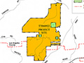
Project Background The Skyline Ranch project site occupies approximately 2,173 acres in unincorporated Los Angeles County. As shown on Figure 3, Approved TTM, the Approved Project includes development on approximately 622 acres of the 2,173-acre site with 1,260 single-family residential lots, an approximately 11.6-acre elementary school site, about 12 acres of public parkland to be dedicated to the Los Angeles County Department of Parks and Recreation, and about 6.2 acres of private parkland. Nearly three-quarters of the site (the northern 1,551 acres) would remain undeveloped, with approximately 1,355 acres dedicated or designated as natural open space through establishment of the proposed Skyline Ranch Conservation Area (SRCA). Approximately 166 acres of undeveloped land in the northern portion of the site would remain undeveloped and designated as Non-development/Continuing Use Area. Also, within the northern portion of the site, approximately 22 acres would be preserved as a Mitigation Exchange Area for 22 acres of preserve area within adjacent recorded Tract 46018 that would be disturbed due to the construction of Skyline Ranch Road. These three areas would preserve approximately 80 percent of the land in the County's Cruzan Mesa Vernal Pools SEA. No development associated with the Skyline Ranch Project would occur in the SEA areas. A proposed trail would extend the existing Mint Canyon Trail from Vasquez Canyon Road to the Plum Canyon Fire Road along an existing dirt path and southwesterly toward a lookout point. The proposed trail easement would run approximately 2.2 miles within portions of the SRCA and Nondevelopment/ Continuing Use Area. The Approved Project would include two miles of hiking trails, one mile of paseo trails, and eight miles of bike lanes. Modified Project Description The Modified Project includes minor technical changes to the approved Skyline Ranch project. Figure 4, Approved TTM vs. Proposed Concept Plan, shows the proposed conceptual site plan, which includes the modifications described below. Figure 5, Development Footprint Comparison, shows an overlay of the Modified and Approved Projects. The Modified Project would have a smaller development footprint within the footprint of the Approved Project. In total, the site would be divided into seventeen planning areas (PAs), designated PA A through Q, one park sites, seven recreation center sites, and one school site (see Figure 6, Modified Conceptual Lot Plan). • Realignment of Skyline Ranch Road. The Modified Project would shift Skyline Ranch Road west of the original alignment. All residential development would be east of the roadway rather than divided by the original alignment. Skyline Ranch Road would maintain its designation as a secondary highway and is proposed to have roundabouts at intersections within the project boundaries. The two access points of Skyline Ranch Road at Plum Canyon Road (to the west) and Sierra Highway (to the southeast) would not change. • Reduction of residential development and inclusion of age-qualified housing. Residential development would be reduced from 1,260 to 1,220 lots (40 fewer units). The homes along the western edge of the property would be removed and/or shifted east of the realigned Skyline Ranch Road, and 284 units of age-qualified housing with a recreation center would be provided in the northern portion of the planned community in PAs G through K. • Modifications to housing product types. A broader range of lot sizes and housing types is now proposed, including smaller, more affordable homes for first-time buyers or move-down buyers that were not included in the original plan. There would be a total of six product types and 1,220 dwelling units. • Relocation of park and recreation sites. The park sites proposed under the Approved Project would be relocated and combined into one large park adjacent to the school, as shown on Figure 4, Approved TTM vs. Proposed Concept Plan. Approximately 16.9 acres of public parkland to be dedicated to the Los Angeles County Department of Parks and Recreation would be relocated to be accessible without crossing streets — in particular without crossing Skyline Ranch Road. Seven recreation centers would be located within the Skyline Ranch community and connected by a multi-purpose trail system. Additionally, the Modified Project includes 2.7 acres of private parkland (a recreation center for age-qualified housing). • Addition of multipurpose trails. The Modified Project would include 10.75 miles of pedestrian connections, which includes 3 miles of hiking trails, a 2.2-mile trail easement, 3.3 miles of paseo trails, and 2.3 miles of multipurpose trails (see Figure 7, Open Space and Trails Map). • Extension of bike lanes. Bike lanes within the Skyline Ranch community would extend from 8 miles to 9.8 miles under the Modified Project. A comprehensive comparison of the Approved and Modified Projects' land use development and housing product types is provided in Tables 2 and 3. Additionally, the Modified Project would reduce the number of basins from 13 to 12, but the 4 water tanks at the northern portion of the developable area under the Approved Project would remain. Overall, the Modified Project would have a reduced development footprint within the Approved Project's development footprint (see Table 2 and Figure 5, Development Footprint Comparison). Compared to the Approved Project, grading quantities would decrease by approximately 18 and 19 percent for cut and fill quantities, respectively. The cut and fill quantities would decrease to approximately 17.1 million cubic yards (cy) cut and 16.9 million cy fill.
Download original pdf here.
|
Draft EIR 7/2009
EIR Addendum 12/2016
Approval Package 12/2016
Superbloom 5/2017
Approval Package 11/2017
|

The site owner makes no assertions as to ownership of any original copyrights to digitized images. However, these images are intended for Personal or Research use only. Any other kind of use, including but not limited to commercial or scholarly publication in any medium or format, public exhibition, or use online or in a web site, may be subject to additional restrictions including but not limited to the copyrights held by parties other than the site owner. USERS ARE SOLELY RESPONSIBLE for determining the existence of such rights and for obtaining any permissions and/or paying associated fees necessary for the proposed use.
