|
Click to enlarge.
|
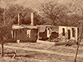
Some four miles north of Lebec, just off the Ridge Route, in the 3,000-foot-high enfoldments of the Tehachapi Mountains, the time-crumbled buildings of old Ft. Tejon are gradually being rehabilitated. Work is progressing slowly due to limited funds but the time is not far off when California residents and visitors from all the globe will be able to see the restored buildings of one of the most unique forts ever established in American history.
The site of Ft. Tejon lies in a grassy, bowl-shaped, tiny valley where giant evergreen oaks stretch out long arms which gave protection against winds and storms for the men in uniform who established the only fort in California where the snow ever covered the ground.
Ft. Tejon was founded Aug. 10, 1854, by Lt. Col. E.F. Beale. It was an outpost in the wilderness, put there to afford protection to persons traveling between Los Angeles and Central California, who were victimized by Indians and outlaw whites. For, following the discovery of the Mother Lode gold fields, human traffic between those points and Los Angeles began gradually to increase.
Toll Road Built
Reaching Ft. Tejon was an arduous task. The government had no money with which to build any kind of trail or road, so Col. Beale made a deal whereby he paid for the building of a crude roadway to the fort and received permission to make it a toll road, upon which he collected fees from every person crossing it. The road was located on the south edge of Fremont Pass, and was operated as a toll road until it was taken into the Los Angeles County road system.
The thousands of motorists who travel up over the Ridge Route today have little concept of the pioneering work done to get roads built across the Tehatchapis [sic]. The first effort to establish public transportation to Ft. Tejon was undertaken when a six-horse stage was so badly smashed in trying to get through Fremont Pass that a large force of Indians was required to repair it so the stage did manage to complete its trip.
Regular Service Resulted
As a result of that first stage coach trip, funds were raised in Los Angeles to widen the road so a regular stage coach service to Ft. Tejon might be established.
We went to Ft. Tejon in luxurious comfort and ease over the Ridge Route, which follows a course different from the old Fremont Pass road in those pioneering days. The Times scout car for this occasion was a 1949 Chrysler New Yorker, furnished by Greene-Haldeman, metropolitan downtown Chrysler-Plymouth headquarters.
Leaving Los Angeles we drove through Glendale and Burbank to San Fernando and Castaic. About 10 miles north of Castaic we found work progressing, in widening the Ridge Route into a separated highway with six-lane traffic lanes. The road improvement operation continues for some 12 miles although there is no delay in traffic movement.
Gorman Convenient
We made a short stop at Gorman, named after Pvt. Gorman who settled there after being discharged from the Army at Ft. Tejon in 1864. We continued on to Lebec, where we had lunch. This point is important to motorists with its hotel, coffee shop, garage and recreational center.
Here also is the Emery Whilton Florafaunium, housing a collection of California's wild flowers, wild birds and animals, collected during 30 years by Emery W. Whilton. It is housed in a building known as the "World's Fair Showcase," moved from the World's Fair at Treasure Island by Kern County. There is a small admission charge to this unusual exhibit.
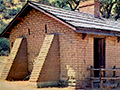
Beyond Lebec about four miles we turned into the grounds of Ft. Tejon, finding that we had traveled 77 miles from Los Angeles. Here we found men at work rebuilding the old military outpost. It is under the direction of Louis Wakefield, who is in charge of the project, for the Ft. Tejon grounds are now a state monument.
28 Restorations Projected
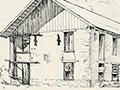
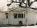
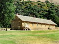
Earl M. Lively, deputy ranger, took us around the old post grounds. Most of the 28 old buildings of Ft. Tejon are to be rebuilt. One is partly finished. This is the main building.
Recently workmen uncovered a deep cellar which had been under the east building of the officers' quarters. It is 12x18 feet. In the ruins they found an old gold-plated watch with Roman numerals, a dozen or more hand-blown bottles and a three-tine, wood-handled fork.
We found workmen, making adobe brick out of the same clay from which those for the original fort were made. Roofs for the buildings are to be covered with shakes, just as the original buildings were roofed, and Indians are now making these by hand cutting near Sequoia.
Ft. Tejon became headquarters for Company A of the 1st Dragoons. The original buildings of the fort were damaged by an earthquake in 1864, when the fort was abandoned [sic; earthquake was 1857].
Camel Test Failed
In 1857 camels brought from the Far East were shipped into the United States and they were used to form the only U.S. Camel Corps and sent to Ft. Tejon. The War Department thought camels could do a better job in the hot Southwest than horses and mules, but this proved false. The camels could not stand walking over rocks.
Once a caravan of 14 was taken to Los Angeles to get supplies. They frightened the populace. When Ft. Tejon was closed the Camel Corps was abandoned. Some camels were sold to circuses, some to pioneers and others wandered away to become a wild herd, which proved a nuisance and which was exterminated gradually.
In 1858 Ft. Tejon became a station stop for the Butterfield Stages and the Butterfield Overland Mail Route, whose six-horse stages covered the distance from San Francisco to St. Louis in 23 days.
Landmarks Stand
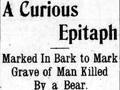
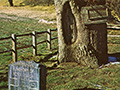
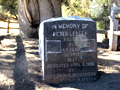
Kit Carson once visited the fort and Lt. Col. John C. Fremont lived there a short time. Landmarks on the grounds include a marker beneath a giant oak tree, recording that Peter le Beck was killed there by a bear in 1837.
In a canyon back of the State monument is a monument to 1st Lt. Thomas F. Castor, Co. A, 1st Reg. U.S. Dragoons, who died there Sept. 8, 1855, at the age of 35.
On the return trip we turned off the main highway near Lebec and visited Frazier Park, a community of mountain homes and cabins and a recreational area where many Los Angeles folk spend their week ends. We came home over the Ridge Route, finding that we had traveled 183 miles for the round trip in our 1949 Chrysler New Yorker.
TRAVELOGUE OF THE WEEK
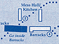
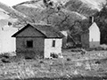
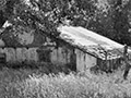
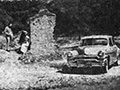
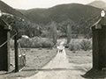
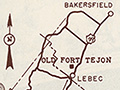
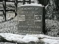
Hidden away, just off the Ridge Route near Lebec, in a canyon shaded by ancient oak trees are the ruins of Ft. Tejon, once an important military post. For many years the old buildings withstood the weather, then they began to gradually crumble away until today there is little left of the grand old fortress. But California has taken over, the fort is now a State monument, and men are rebuilding it. A trip to this colorful area was made by the Times scout party in a 1949 Chrysler New Yorker from Greene-Haldeman, Los Angeles Chrysler-Plymouth headquarters, to view the progress being made at the fort's restoration. Upper left [second photograph], Castaic Lake seen from the Tejon Ranch. Center [bottom photograph], members of the party inspect grave of Peter Lebec. Below [top photo], restored main building of the fort seen through ruins of outer buildings. Map of route below shows how to reach the area.
Note: "Castaic Lake" is the natural water body at Lebec. The manmade Castaic Lake Reservoir did not yet exist.
|