|
|


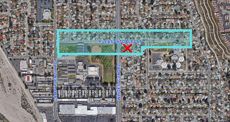
Starting in 1946, the 6-S Ranch Airpark was located on top of today's Pleasantdale Street in Canyon Country. Camp Plenty Road existed at the time; Whites Canyon Road did not. (Neither did Pleasantdale Street or the other residential streets). Instead of sporting homes, the surrounding acreage was plowed for row crops. "X" marks the spot of the airport buildings, which can be seen in the 1961 horror film, "The Beast of Yucca Flats," which actually opens on the airstrip The southwestern portion of the airpark property would become the north end of the Sierra Vista Junior High School campus. The southeastern portion would become the north side of Canyon Springs Community School. About the 6-S Ranch Airpark
Helm and Earle Schmidt opened an airport in 1946 on the 1,800-acre 6-S Ranch, which had previously been owned by the grandson and namesake of the pioneer Los Angeles 20-Mule team freighter, Remi Nadeau. It was known as Nadeau Deer Farm and was, for years, one of the famous sights of northern Los Angeles county. The airfield sat to the northwest of the modern-day intersection of Soledad Canyon and Whites Canyon Roads. Following Helm Schmidt's death in 1960, the acreage was sold and developed into the North Oaks tract, which began construction in 1961. It was the Santa Clarita Valley's second housing tract — the first being the 15-home "Rancho Santa Clarita" subdivision that the William Bonelli family built in Seco (Dry) Canyon in 1947. By 1963, the North Oaks area, which had previously been considered a part of Saugus, was starting to achieve its own identity as "Canyon Country." The name became official in 1968 when the Canyon Country Post Office opened near Solemint Junction (the intersection of Soledad Canyon Road and Sierra Highway).
6-S Ranch Airpark featured in "The Beast of Yucca Flats" "Plan 9 from Outer Space," starring Eternal Valley Cemetery resident Tor Johnson, was voted the worst movie of all time. Sorry, but we’ve got it beat with this 1961 Tor Johnson feature, "The Beast of Yucca Flats," which actually IS the worst movie of all time. Bonus: It was filmed almost entirely in the Santa Clarita Valley, particularly Canyon Country, when Canyon Country was little more than sagebrush, rattlesnakes, and the 6-S Ranch Airpark.
SEE ALSO:
LW2918: 9600 dpi jpeg extrapolated from HistoricAerials.com.
|
About Earl Schmidt
Built Airplane 1928
6-S Ranch Airpark, Shell Progress 1947
6-S Ranch Airpark ~1950s
6-S Ranch Airpark in "China Doll" (1958)
6-S Ranch Airpark in "The Beast of Yucca Flats" (1961)
Location of 6-S Ranch Airpark
Helm Schmidt Home in Newhall 1961
Looking South 1968
Newberry's, Alpha Beta ~1970s
Aerial: Whites 1979
Whites Canyon Bridge Construction 1988
|
The site owner makes no assertions as to ownership of any original copyrights to digitized images. However, these images are intended for Personal or Research use only. Any other kind of use, including but not limited to commercial or scholarly publication in any medium or format, public exhibition, or use online or in a web site, may be subject to additional restrictions including but not limited to the copyrights held by parties other than the site owner. USERS ARE SOLELY RESPONSIBLE for determining the existence of such rights and for obtaining any permissions and/or paying associated fees necessary for the proposed use.


